
Srinagar District: Geography, History and Cultural Overview
A sourced introduction to Srinagar district, its river and lakes, gardens, religious heritage, crafts, public institutions and regional connections.
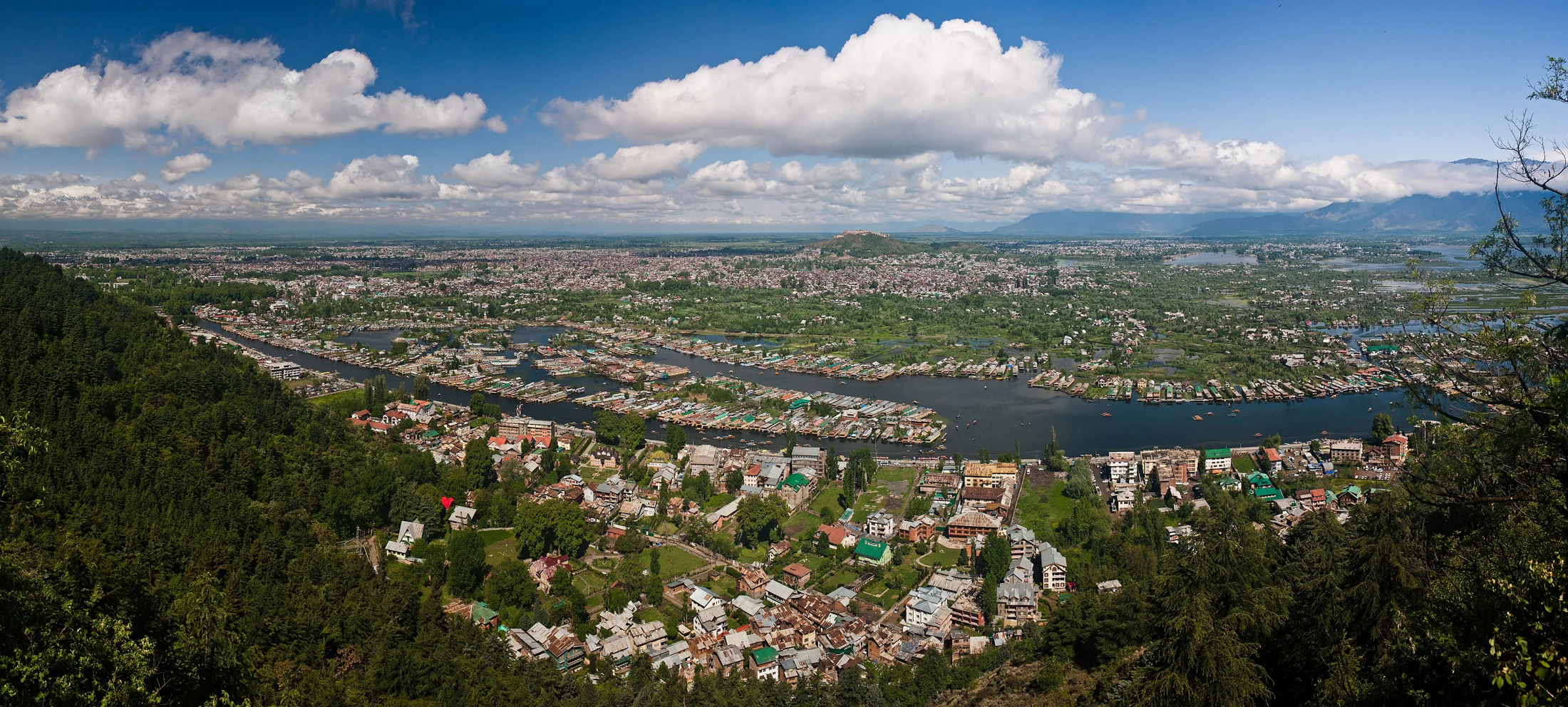
Srinagar district and the city at its centre
Srinagar is a district of Jammu and Kashmir in the Kashmir region. Its principal city, also called Srinagar, is the union territory’s summer capital. The district’s identity is closely connected with the Jhelum River, lakes, gardens, religious buildings and craft traditions. A district overview must nevertheless distinguish the administrative district from the city, the municipal area and the wider urban landscape. These are related geographical units, but their boundaries and statistical totals are not interchangeable. [1]
The district is an appropriate starting point for understanding the connections between Kashmir’s natural environment and its urban culture. Lakes appear in photographs, rivers connect neighbourhoods, and artisan work gives material form to inherited skills. This entry introduces those connections; specialised articles can examine individual places and practices in greater detail.
Geographical setting
The district administration places the city near the centre of the Kashmir Valley and gives its elevation as approximately 1,585 metres above sea level. The Jhelum, locally known as Vyath, passes through Srinagar, with settlement on both banks. Bridges connect the two sides and are important features of the urban landscape. The elevation describes the city approximately; it should not be treated as the height of every location in the district. [1]
For a reader looking at a map, the useful distinction is between a point marking a city location and a boundary representing a district. The map supplied with this entry marks the documented photographic viewpoint on Shankaracharya Hill at 34.083926, 74.845176. It is a representative location associated with the cover photograph, not a surveyed district centroid or an administrative boundary. The coordinates come from the photograph’s Wikimedia Commons metadata. [2]
![[2]](https://commons.wikimedia.org/wiki/File:Srinagar_pano.jpg)
District administration and local divisions
The district portal maintains separate information for its administration, tehsils, subdivisions and public services. Its published tehsil list includes Central Shalteng, Chanapora/Natipora, Eidgah, Khanyar, Pantha Chowk, Srinagar North and Srinagar South. These names describe administrative divisions and should not automatically be presented as a complete list of neighbourhoods or tourist destinations. [3]
Administrative lists can change. Applications, certificates and jurisdiction questions should therefore be checked against the district administration’s current notices. Older population figures also need an explicit census year and geographical unit. This article avoids presenting a historical census total as today’s population.
Lakes, houseboats and the waterside landscape
Dal Lake and Nigeen Lake are prominent elements of Srinagar’s landscape. The district’s places-of-interest directory identifies both, together with gardens and other landmarks around the city. Dal is particularly associated with houseboats. Water, accommodation and recreational activity meet here, making the lake relevant to geography, local livelihoods and tourism rather than only to scenic photography. [4]
The cover panorama shows the lake and city from a hilltop perspective. Its date is 19 April 2010, so it documents an earlier view, not present-day development or water conditions. Historical photographs are valuable precisely when their dates are retained. A picture’s beauty does not make it evidence for current environmental measurements.
Gardens and historical landscape
Srinagar’s Mughal gardens connect the city with a wider tradition of garden design across the subcontinent. The district directory includes Shalimar, Nishat and Chashma Shahi among its places of interest. A useful way to read these landscapes is to consider their setting, terraces, water features and relationship with surrounding views. They are built environments as well as spaces for recreation. [4]
The district tourism directory also lists Badamwari, Harwan, the Botanical Garden, the Tulip Garden and Pari Mahal. These places have different histories and functions; they should not all be described as Mughal gardens. The list helps readers navigate a varied landscape of historic sites, cultivated gardens and seasonal attractions. [5]
Historical context
Srinagar’s history belongs to the wider history of Kashmir, but a responsible overview should distinguish established chronology from traditions about ancient origins. The Jammu and Kashmir Planning Department’s historical account records Kashmir’s incorporation into the Mughal Empire in 1586. The city’s surviving gardens provide one accessible route into that period, while religious architecture and older urban areas open other lines of enquiry. [6]
An encyclopedia should avoid assigning a single construction date to an entire building complex without examining its rebuilding, restoration and later additions. Similarly, a palace’s present use does not by itself explain its earlier political or social role. Detailed entries on monuments will need site-specific evidence beyond this introductory district account.
Faith, sacred places and architecture
The Ministry of Tourism’s Srinagar overview identifies Jamia Masjid, the Shah Hamdan shrine and Hazratbal among the city’s Islamic heritage sites. It also identifies Shankaracharya Hill and its temple as a prominent religious location. These sites belong in a district encyclopedia as places of worship, cultural memory and architecture, with religious beliefs attributed respectfully rather than presented as independently verified historical facts. [7]
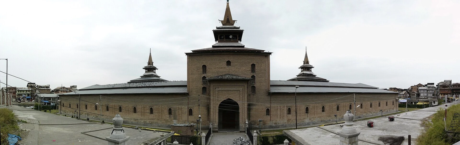
Jamia Masjid is notable in that overview for its wooden architecture. The photograph included here shows its eastern facade and was taken in September 2011. It records a specific view at a specific time. Visitors should follow local worship arrangements and ask before photographing people or religious activity; permission for a building photograph does not imply permission to photograph everyone inside it.
.jpg)
Crafts and their economic importance
Srinagar joined UNESCO’s Creative Cities Network in 2021 in the field of Crafts and Folk Art. UNESCO describes craft production as an important source of income, employment and social connection. This recognition concerns a living creative economy: makers, skills, workplaces and opportunities for new generations. It is not a World Heritage Site designation. [8]
The district’s craft directory identifies pashmina, hand-knotted carpets, walnut wood carving, papier-mâché, sozni embroidery, kani weaving and copperware. These practices use different materials and techniques. Papier-mâché combines formed paper material with painted decoration; wood carving works timber; embroidery decorates textiles with needlework. An encyclopedia should preserve these distinctions instead of describing every product simply as a souvenir. [9]
The same directory points to Lal Chowk, Polo View, Residency Road and Zaina Kadal as shopping areas. It advises buyers to check recognition, certification and billing. A product’s marketing label alone is not proof of its fibre, workmanship or geographical origin.
Music, performance and cultural expression
The district’s culture page describes Bhand Pather as a folk theatre tradition bringing together performance, dance and social satire. It identifies Chakri as a Kashmiri folk-music form and discusses Sufiana music as another part of the region’s musical heritage. These traditions offer different forms of storytelling and artistic expression. [10]
Culture should not be reduced to a single costume, festival or photograph. An overview can introduce a tradition, but specialist articles should distinguish historical accounts, current practice and the experience of particular performers. Contributor interviews can add depth when the interviewee, date, context and permission are recorded.
Wetlands and wildlife connections
The district’s geography page draws attention to Hokersar near Srinagar and to migratory birds using Kashmir’s wetlands. It lists several ducks and geese associated with that habitat, including mallard, gadwall, northern pintail and greylag goose. Wetlands therefore belong in the regional encyclopedia as ecological places, not merely as excursions from the city. References to a wetland “near Srinagar” should not be mistaken for a definitive statement that every part lies within the district boundary. [11]
Dachigam National Park provides another connection between Srinagar and wildlife. The district’s park entry records protection beginning in 1910 and national-park status in 1981. It identifies the park particularly with the hangul, or Kashmir stag, and notes its historical connection with supplying clean water to the city. Wildlife observation and conservation need separate treatment from ordinary park recreation. Access rules should be checked with the responsible authority. [12]
Transport and regional connections
Srinagar is reached by air, rail and road. Sheikh ul-Alam International Airport serves the city, and Srinagar railway station is part of the Udhampur–Srinagar–Baramulla rail corridor. The district’s transport page describes road access through National Highway 44 and identifies the Tourist Reception Centre among its bus-related locations. [13]
Exact train origins, stops, flight schedules, fares, taxi availability and bus departures are changing operational information. Readers should verify them with the relevant operator before travel. This entry intentionally avoids reproducing fixed journey times or presenting a transport website’s sample itinerary as a guaranteed service. Roads may be affected by weather and landslides; a route’s existence does not guarantee uninterrupted access.
Education and public services
The district’s college directory includes Amar Singh College in Gogji Bagh, Abdul Ahad Azad Memorial Degree College in Bemina, Gandhi Memorial College and the Government College for Women on M.A. Road. These are examples of listed institutions, not a complete inventory of education in the district. Admission requirements and current programmes should be checked with the institutions themselves. [14]
The hospital directory includes SMHS Hospital, Lal Ded Hospital, the Government Children Hospital in Bemina and the Government Bone and Joint Hospital, among other facilities. Inclusion here is geographical and informational, not a ranking or medical recommendation. Department availability, referrals and emergency access must be confirmed through the appropriate current service. [15]
Photograph attribution
The cover image is by KennyOMG, via Wikimedia Commons, licensed CC BY-SA 3.0. It has been resized and converted to WebP; scene content is unchanged.
Reading Srinagar through connected subjects
A district overview is an entry point rather than an exhaustive catalogue. Follow the linked topic searches for its lakes, monuments, craft traditions and natural areas. As dedicated entries are approved, those searches can be replaced with direct article cross-references. Keeping sources, photograph dates and geographical scope visible allows the collection to grow without turning provisional information into permanent fact.
Research date: 13 October 2026. Source pages have different publication and update dates. The article introduces documented subjects; it does not claim that every older directory entry has been independently reconfirmed with its operator.
Sources & references
[1] About District
https://srinagar.nic.in/about-district/ ↗
[2] Cover photograph and viewpoint metadata
https://commons.wikimedia.org/wiki/File:Srinagar_pano.jpg ↗
[3] Tehsils
https://srinagar.nic.in/tehsil/ ↗
[4] Places of Interest
https://srinagar.nic.in/places-of-interest/ ↗
[5] Tourist Places
https://srinagar.nic.in/tourist-places/ ↗
[6] J&K historical account
https://jkplanning.gov.in/history.html ↗
[7] Ministry of Tourism: Srinagar
https://www.incredibleindia.gov.in/en/jammu-and-kashmir/srinagar ↗
[8] UNESCO Creative Cities: Srinagar
https://www.unesco.org/en/creative-cities/srinagar ↗
[9] Local Craft
https://srinagar.nic.in/local-craft/ ↗
[10] Culture & Heritage
https://srinagar.nic.in/culture-heritage/ ↗
[11] Geography & Demography
https://srinagar.nic.in/demography/ ↗
[12] Dachigam National Park
https://srinagar.nic.in/tourist-place/dachigam-national-park/ ↗
[13] How to Reach
https://srinagar.nic.in/how-to-reach/ ↗
[14] Colleges
https://srinagar.nic.in/public-utility-category/colleges/ ↗
[15] Hospitals
https://srinagar.nic.in/public-utility-category/hospitals/ ↗