
Batamaloo: Neighbourhood and Changing Bus-transport Geography
Batamaloo, also written Batmaloo, is a neighbourhood in Srinagar with a strong historical association with passenger buses. Its former major bus stand appears in older travel descriptions. The locality continues to have its own identity even when the location of an important transport function changes. A neighbourhood should not be reduced to the operating history of one facility.
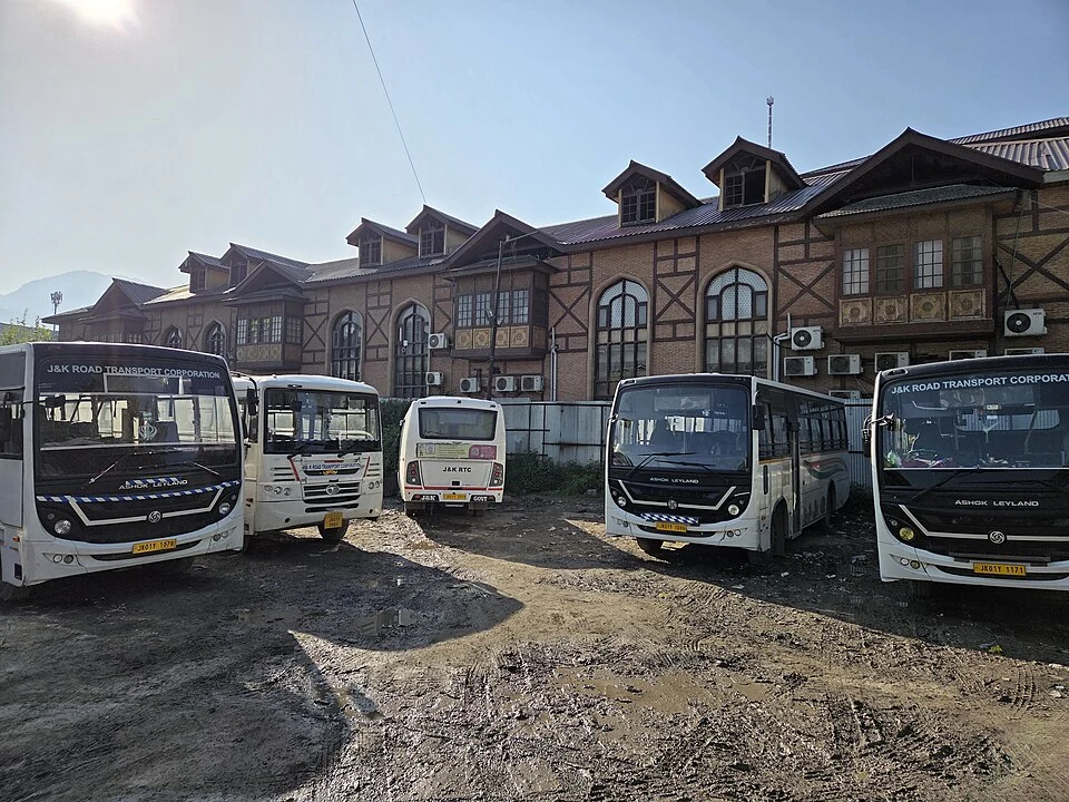
Batamaloo, also written Batmaloo, is a neighbourhood in Srinagar with a strong historical association with passenger buses. Its former major bus stand appears in older travel descriptions. The locality continues to have its own identity even when the location of an important transport function changes. A neighbourhood should not be reduced to the operating history of one facility. [1]
A dated transport change
Reporting from September 2017 described the shift of transporters from the Batamaloo bus stand to Parimpora. This provides a dated explanation for conflicting directions in older and newer sources. It does not support a present claim that all buses, every operator or every local service now use one replacement terminal. [2]
Names can remain familiar long after an institutional move. A resident may use an established landmark in conversation, while an operator gives a different boarding address. Historical familiarity and practical accuracy are therefore separate issues. For travel, the actual pickup confirmation is the more precise information.
Neighbourhood life and transport
A bus stand concentrates journeys into a limited area. Passengers, vehicles and surrounding businesses can become closely associated with it. When studying a relocation, these relationships are useful questions, but the answers require evidence about specific businesses and periods rather than a sweeping claim that the entire neighbourhood became inactive.
Batamaloo can be compared with Lal Chowk and older Srinagar neighbourhoods to understand different urban functions. A commercial centre, a residential locality and a transport interchange may share streets without having identical boundaries. Mapping a former bus stand is not the same as mapping the whole neighbourhood.
Interpreting older guides
Check the publication date before using a transport description. An old photograph or guide can document Batamaloo’s former bus role without serving as current travel advice. The map marker here gives locality context and is not presented as an operating terminal entrance. Cross-reference Parimpora for the documented relocation and the operator’s current information for departures. This approach preserves the neighbourhood’s transport history while avoiding directions based on a service arrangement that may have changed.
Image and map record
Image: Gannu03 via Wikimedia Commons. Licence: CC BY-SA 4.0. Recorded capture date: 14 April 2025 (according to Exif data). Resized and converted to WebP; image content unchanged. This is a dated view, not confirmation of the site’s present appearance.
Map marker: 34.0687, 74.7783. Source-recorded orientation point, not a surveyed boundary, verified visitor entrance, campsite or present access guarantee. View location on OpenStreetMap · View Google Maps · Google directions · OpenStreetMap directions.
Research checked: 15 October 2026. For a visit, confirm current access, transport and opening information with the relevant authorities. This encyclopedia profile provides geographical and historical context.
Sources & references
[1] Wikipedia: Batamaloo (secondary overview)
https://en.wikipedia.org/wiki/Batamaloo ↗
[2] The Tribune: transporters shift to Parimpora, September 2017
Image and licence
https://commons.wikimedia.org/wiki/File:Srinagar_bus_station_(45399).jpg ↗
Related reading
Aali Masjid: Open Ground and a Historic Srinagar Mosque
Aali Masjid, also written Ali Masjid, is a historic mosque in Srinagar's Eidgah area.

Agha Shahid Ali: Poetry, Memory and Kashmir
Agha Shahid Ali was a Kashmiri-American poet who lived from 1949 to 2001. Born in New Delhi and raised in a family associated with Kashmir, he develop
Amar Singh College: Education, Campus Heritage and Institutional Change
The growth of an educational institution from a technical institute, with campus conservation and academic resources.