
Dalgate: Srinagar’s Lake Outlet and Urban Junction
Dalgate is a place-name used for the urban junction beside the southern end of Dal Lake in Srinagar. It brings lake geography into direct contact with roads, built-up streets and journeys between different parts of the city. The name is associated with the lake’s outlet setting; this entry treats Dalgate as an urban locality, not as another name for the entire lake.
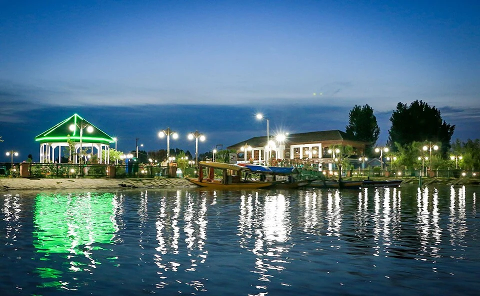
Dalgate is a place-name used for the urban junction beside the southern end of Dal Lake in Srinagar. It brings lake geography into direct contact with roads, built-up streets and journeys between different parts of the city. The name is associated with the lake’s outlet setting; this entry treats Dalgate as an urban locality, not as another name for the entire lake. [1]
A lake within a city
Official descriptions of Dal Lake place it within Srinagar’s recreational and working landscape. Lake-side life includes more than scenic views: water, shore development and movement between land and boats all shape how nearby places function. Dalgate should therefore be understood through the relationship between a waterbody and its surrounding city. [2]
The edge of a lake is not a simple line in daily experience. Roads and buildings can separate a pedestrian from the water, while a boat landing provides a connection at a particular point. A photograph taken from a lakeside road does not establish unrestricted public access along every adjacent section of shoreline.
Place-name and orientation
A district filter answers where an encyclopedia entry belongs administratively; a neighbourhood name helps readers locate a smaller urban setting. Dalgate belongs under Srinagar, but a marker is only a reference point. It should not be used to draw an exact boundary around residences, transport stops or the lake’s hydraulic infrastructure.
The urban junction is also distinct from a named boat landing. Travellers arranging a shikara journey need the agreed boarding point, while people seeking an office or hotel need its address. Substituting the general locality for either can produce an inaccurate route even when the place-name itself is correct.
Connections across the encyclopedia
Read Dalgate with Dal Lake, the Jhelum and Srinagar’s neighbourhood entries. Together they show how water and street networks overlap without becoming interchangeable. Entries on drainage should identify the named channel and source evidence; entries on businesses should use their own verified location. This preserves a useful distinction between landscape explanation and a directory of services. The accompanying dated image provides visual context only; its caption identifies the actual recorded subject rather than claiming to portray all of Dalgate.
Image and map record
Image: Abid Sidiq Ahanger via Wikimedia Commons. Licence: CC BY-SA 4.0. Recorded capture date: 2019-05-19. Resized and converted to WebP; image content unchanged. This is a dated view, not confirmation of the site’s present appearance.
Map marker: 34.083, 74.797. Labelled regional/locality context marker; not a verified public entrance, pickup point, birthplace, residence, venue, trailhead, crop boundary or visitor route. View location on OpenStreetMap · View Google Maps · Google directions · OpenStreetMap directions.
Research checked: 15 October 2026. For a visit, confirm current access, transport and opening information with the relevant authorities. This encyclopedia profile provides geographical and historical context.
Sources & references
[1] Wikipedia: Dal Lake (secondary overview)
https://en.wikipedia.org/wiki/Dal_Lake ↗
[2] Divisional Commissioner Kashmir: Dal Lake
https://divcomkashmir.jk.gov.in/tourist-place/dal-lake/ ↗
Image and licence
Related reading
Aali Masjid: Open Ground and a Historic Srinagar Mosque
Aali Masjid, also written Ali Masjid, is a historic mosque in Srinagar's Eidgah area.

Agha Shahid Ali: Poetry, Memory and Kashmir
Agha Shahid Ali was a Kashmiri-American poet who lived from 1949 to 2001. Born in New Delhi and raised in a family associated with Kashmir, he develop
Amar Singh College: Education, Campus Heritage and Institutional Change
The growth of an educational institution from a technical institute, with campus conservation and academic resources.