
Dal Lake: Waterways, Floating Gardens and Life on the Lake
An introduction to Dal Lake’s connected basins, working waterscape, floating gardens, boats and cultural setting.
An urban lake and a working landscape
Dal Lake is a major water body in Srinagar whose significance extends beyond its role as a scenic destination. Fishing, aquatic-plant harvesting, boats, accommodation and recreation all form part of its relationship with the city. The district administration describes the lake as an important setting for both commerce and tourism. Its shores connect parks, hotels and gardens with households, work and visitors. [1]
Basins, islands and neighbouring waters
The lake is not simply a single, undivided pool. The district account names Gagribal, Lokut Dal and Bod Dal among its basins and discusses Nagin as both part of the connected system and a lake considered separately. That distinction explains why Nigeen Lake has its own entry in this encyclopedia. The same account identifies Rup Lank, also known as Char Chinari, and Sona Lank as islands associated with different basins. [1]
Water-area figures require a definition: open water, wetland and floating gardens do not necessarily produce the same total. The administration’s descriptive page gives approximately 18 square kilometres for the lake and a larger figure for the surrounding wetland. These are published reference figures, not a new measurement of present-day extent. [1]
Floating gardens and everyday production
Floating gardens, known locally through spellings such as rad or raad, are among Dal’s distinctive features. The Ministry of Tourism describes them as patches made with vegetation and soil, positioned and anchored on the water. Its account mentions vegetables grown in these plots, including tomatoes and cucumbers. They demonstrate that water can support cultivated space as well as boat movement. [2]
The floating market and working boats should be understood in that context. A visitor sees a scene, but residents also use the lake for practical purposes. Taking photographs respectfully means recognising that a boat carrying produce or a person tending a plot is not merely a tourist performance. Ask before close portraits and avoid interrupting someone’s work.
Shikaras and houseboats
A shikara and a houseboat perform different functions. Shikaras are smaller wooden craft associated with moving people and goods; houseboats are accommodation spaces. The J&K Tourism Development Corporation describes boat rides, waterside stays and the lake’s connection with the city’s visitor economy. Comparing accommodation should involve the actual operator, landing point and facilities rather than assuming every vessel offers the same experience. [3]
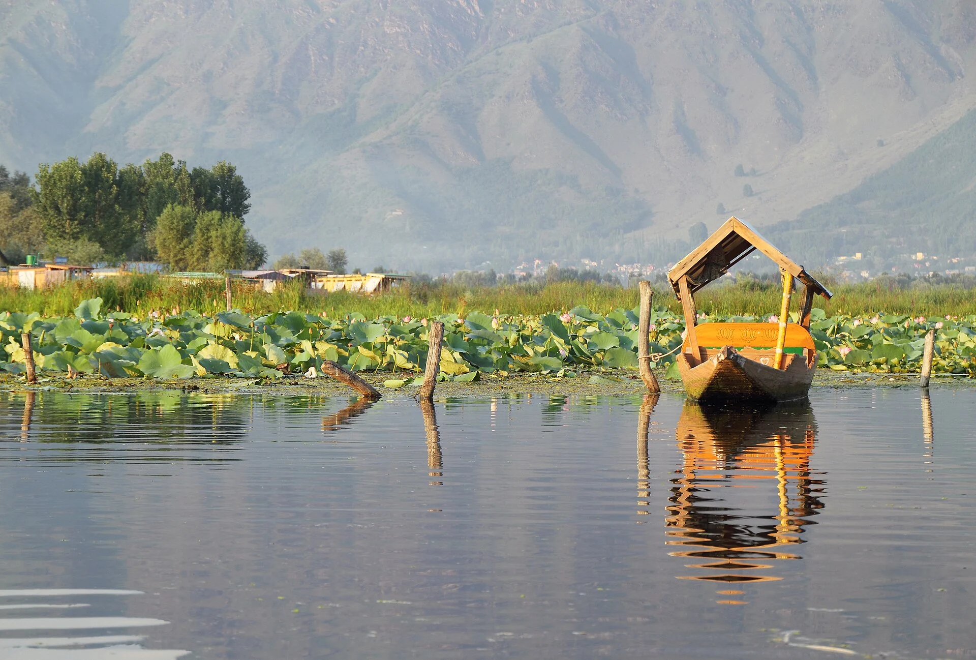
The photograph accompanying this entry shows an empty shikara on Dal in August 2013. Its low viewpoint emphasises the relationship between the boat, water vegetation and surrounding hills. The image is a dated record of one scene; it does not establish today’s water quality, boat availability or operating conditions. [4]
![[4]](https://commons.wikimedia.org/wiki/File:Empty_shikara_on_Dal_Lake,_Srinagar,_India_2013-08-23_(flickr_9967093983).jpg)
Gardens and the surrounding cultural landscape
Shalimar Bagh and Nishat Bagh provide complementary ways to understand the lake: their landscape design makes water and distant views part of the visitor’s experience. Pari Mahal offers another connection between built heritage and the surrounding basin. Read their individual entries for historical details instead of treating the shoreline as one undifferentiated attraction. [2]
Planning a visit
Choose a specific landing or shore destination before arranging transport. A route to a houseboat, a garden entrance and a lakeside viewpoint may have different final approaches. Confirm a boat’s agreed duration, fare and safety arrangements with the operator; do not rely on an old photograph or a general guide for those details. Use current weather and local access information, keep waste out of the water and respect residential areas. The map pin for this entry follows the photograph’s geotag, identifying a representative location rather than the entire lake boundary.
Photograph credit and map
Photograph: Fulvio Spada from Torino, Italy, via Wikimedia Commons, CC BY-SA 2.0. Resized and converted to WebP; no scene elements altered. Recorded date: 2013-08-23 14:55.
Map marker: Photo geotag; representative point, not lake boundary.
For regional airport, railway and bus connections, consult the district transport guide.
Research date: 13 October 2026. Confirm changing access arrangements before travelling.
Sources & references
[1] District Srinagar — Dal Lake
https://srinagar.nic.in/tourist-place/dal-lake/ ↗
[2] Ministry of Tourism — Dal Lake
https://www.incredibleindia.gov.in/en/jammu-and-kashmir/srinagar/dal-lake ↗
[3] JKTDC — Dal Lake
https://jktdc.co.in/Dal-Lake.aspx ↗
[4] Photograph source and licence
[5] District Srinagar — regional transport guide
Related reading
Chashma Shahi: The Royal Spring and Its Mughal Garden
The spring-centred design, Mughal commission, traditions and setting of Chashma Shahi.
Dachigam National Park: Landscape, Hangul and Conservation
Dachigam’s protection history, varied terrain, water connections and wildlife-conservation context.
Hazratbal Shrine: Devotion, History and Lakeside Architecture
Hazratbal’s devotional traditions, relic associations and the history of its lakeside architectural setting.
Referenced by
- Nigeen Lake: Connections, Localities and Waterside Life
- Jhelum River in Srinagar: Vyath, Crossings and Riverfront Heritage
- Shalimar Bagh: Mughal Patronage, Water and Garden Architecture
- Nishat Bagh: Terraces, Water and the Dal Lake Landscape
- Chashma Shahi: The Royal Spring and Its Mughal Garden
- Pari Mahal: Dara Shikoh, Learning and Terraced Architecture
- Hazratbal Shrine: Devotion, History and Lakeside Architecture
- Dachigam National Park: Landscape, Hangul and Conservation
- Gulmarg: Meadow, Resort History and Winter Sports
- Wular Lake: Flood Storage, Wetland Ecology and Livelihoods
- Mansar Lake: Sacred Shores and the Surinsar–Mansar Wetland