
Kargil District: Settlement, Trade and Administrative History
Kargil’s district history, mountain settlement, trade heritage and the distinction between older descriptions and the 2026 district changes.
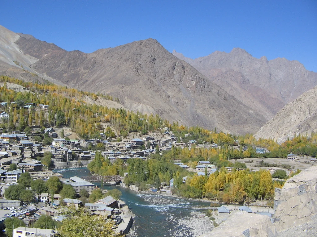
Kargil is a district of Ladakh, with its administrative headquarters in Kargil town. The town and the district share a name but are not the same geographical unit. This entry introduces their relationship, the history of district administration and the regional trade and settlement landscape. It also distinguishes older district descriptions from the administrative changes notified in 2026, so that historical information is not mistaken for a current boundary statement.
District formation and administrative change
The district administration’s history page records Kargil’s formation as a separate district in 1979, through division of the earlier Leh district. It also dates the establishment of the Ladakh Autonomous Hill Development Council, Kargil, to July 2003. These milestones describe important stages in local administration. Counts of blocks or other units on that older page should not automatically be carried forward as present-day figures.[2]
On 27 April 2026, the Ladakh administration announced notification of five new districts: Sham, Nubra, Changthang, Zanskar and Drass. The announcement describes Ladakh’s expansion from two districts to seven. This is why older Kargil pages referring to a two-district Ladakh need to be read as legacy descriptions. This entry does not reproduce their older area or village totals as verified measurements of the post-notification district.[4]
Mountain settlement and water
The district’s legacy geographical account describes a mountain environment where settlements depend on available land and irrigation. It notes that a village may comprise dispersed household clusters rather than a single compact group of houses. Snow and glacier-fed water, short growing seasons and restricted cultivable ground are important elements of this regional picture. These observations remain useful background, while the historical extent attached to that account requires separate boundary checking.[1]
The map marker for this article identifies Kargil town, the district headquarters, using the town’s secondary geographical reference. It does not define a district polygon or identify its geographical centre. Keeping this distinction explicit allows readers to use the map for orientation without confusing a single point with an administrative territory.[5]
Trade and cultural heritage
The tourism account describes Kargil as a historical meeting point for traders carrying goods such as tea, wool, silk, carpets and precious stones. It also identifies a heritage landscape containing Buddhist images, rock carvings, mosques, monasteries, forts and other monuments. These associations show why regional history should include trade, religion and building traditions alongside the better-known modern association with the 1999 conflict.[3]
The same account dates Ladakh’s opening to tourism to 1974 and the establishment of a Kargil tourist office to 1975. Its older visitor tables are historical records rather than a current measure of tourism. A district profile benefits from this chronology without turning past statistics into claims about today’s economy.[3]
Connected reading
Sonamarg introduces the Kashmir-side mountain corridor towards Ladakh. Leh Palace explores royal architecture elsewhere in the region. These cross-references connect different scales of geography and history; neither replaces a detailed account of individual villages, roads or monuments within Kargil.
Photograph and map record
Photograph: Saurabh Lall via Wikimedia Commons. Licence: CC BY 2.0. Recorded capture date: 2005-10-28. Resized and converted to WebP; scene content unchanged. This is a dated view, not confirmation of the site’s present appearance.

Map marker: 34.5594, 76.1256. Secondary geographical reference for Kargil town, the headquarters; not the district centre or boundary. View location on OpenStreetMap.
Research checked: 13 October 2026. For a visit, confirm current access, transport and opening information with the relevant authorities. This encyclopedia profile provides geographical and historical context.
Sources & references
[1] District Kargil — About district; legacy geographical extent
https://kargil.nic.in/about-district/ ↗
[2] District Kargil — History
https://kargil.nic.in/history/ ↗
[3] District Kargil — Tourism and heritage
https://kargil.nic.in/tourism/ ↗
[4] UT Ladakh — Five new districts notified, 27 April 2026
[5] Kargil town — secondary locator reference
https://en.wikipedia.org/wiki/Kargil ↗
Photograph and licence
https://commons.wikimedia.org/wiki/File:Kargil_Town_Panorama.jpg ↗
Related reading
Srinagar District: Geography, History and Cultural Overview
A sourced introduction to Srinagar district, its river and lakes, gardens, religious heritage, crafts, public institutions and regional connections.