
Krimchi Temples: Stone Architecture in the Udhampur Hills
The group of stone temples in Udhampur, with distinctions between local tradition and archaeological evidence.
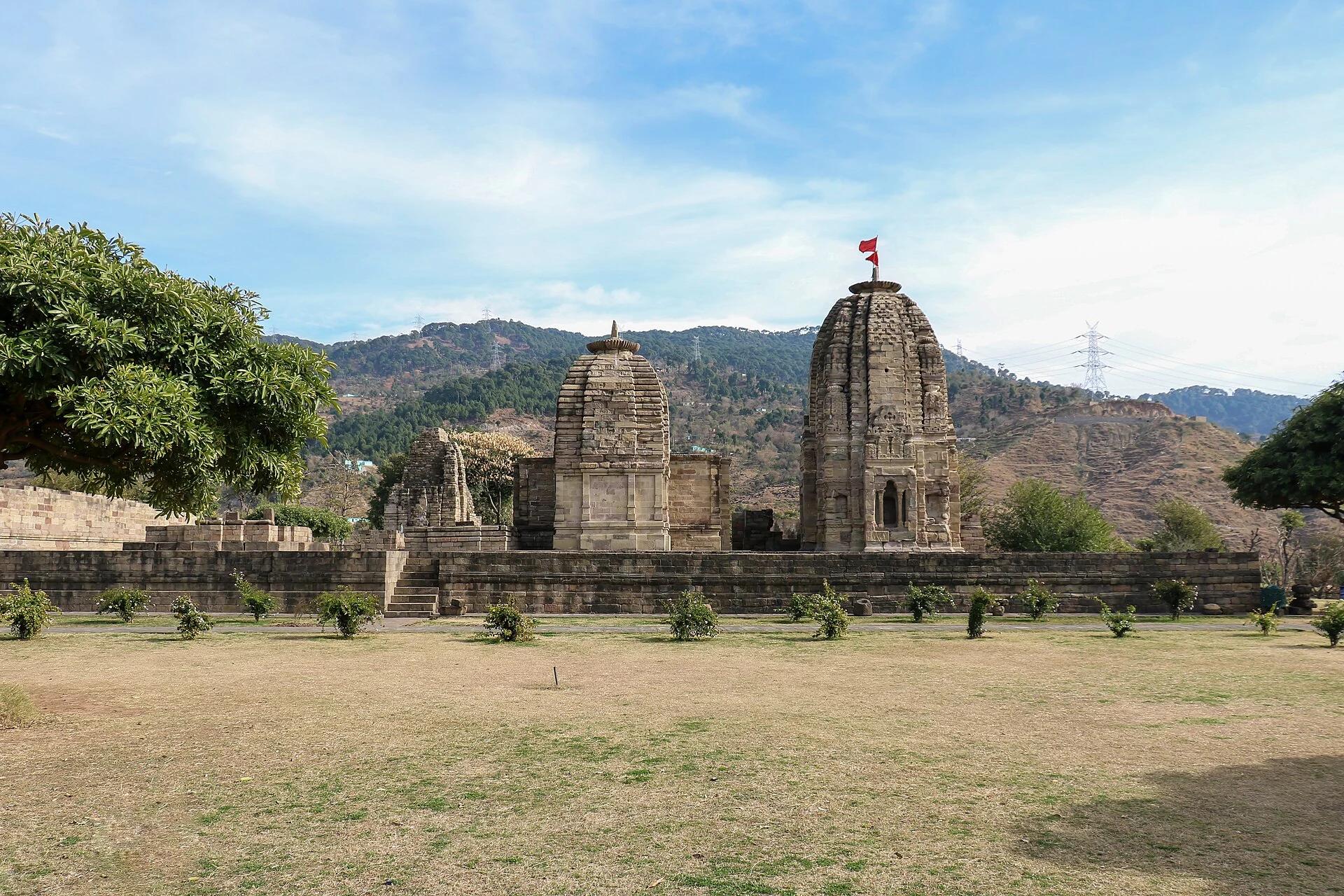
The Krimchi temple group lies in the Udhampur hills in the Jammu region. Krimchi, Krimachi and Kiramchi are spellings encountered in local and official descriptions. The district administration identifies a group of five temples and two smaller shrines near the village, rather than one solitary monument. Its stone architecture gives the site an important place in the region’s archaeological landscape.[1]
A group within a small valley
The Udhampur account places Krimchi beside local streams and green hills, with an approach from the Udhampur–Lander side. The setting matters because the monuments stand within a valley and village landscape, not a large urban enclosure. The spaces between the structures are part of the group’s layout and should be considered alongside the individual towers.[1]
The secondary temple reference describes stone-built shrines with features associated with north Indian temple architecture. Their surviving form includes rising towers, entrances and carved details. A study of the ensemble needs to distinguish the components of each shrine from the overall organisation of the group.[2]
Tradition and archaeological chronology
The district account records local traditions relating the place to the Pandavas and to older regional rulers. Such traditions contribute to the site’s remembered history. They should not be used without qualification as a secure construction date for every temple. Architectural comparison, inscriptions where available and archaeological study provide different kinds of evidence from an epic association.[1]
The secondary account places the surviving temples broadly within the early medieval historical discussion of the region. This general chronology is more useful than an unsupported exact year for the whole group. Separate shrines may have different histories of construction, repair and use even where they are now visited together.[2]
Looking at the standing remains
The photograph shows an open site with standing stone shrines, lower remains and wooded hills in the background. The variation in height and completeness makes the group’s different components visible. It is a dated record of the site, not a reconstruction of all the buildings as they originally stood.
Stone monuments can remain legible while losing roofs, upper members or decorative fragments. Understanding a plan from the ground and understanding a tower from its exterior are complementary tasks. The gaps in the surviving fabric should be recognised as gaps rather than filled with an imagined design presented as fact.
Heritage interpretation
A district report documents a heritage walk involving Shri Mata Vaishno Devi University, the Patnitop Development Authority and the Archaeological Survey of India. The event illustrates the site’s use for historical learning as well as visitor interest. It is a record of one organised activity, not a promise of a regularly scheduled public tour.[3]
Compare Martand and Awantipora for other stone temple ensembles. Shiv Khori offers a different sacred setting based on a natural cave, while Amar Mahal illustrates a later built environment and public institution in the Jammu region.
Photograph and map record
Photograph: Ajitakshaya via Wikimedia Commons. Licence: CC BY-SA 4.0. Recorded capture date: 2016-01-09 13:24:50. Resized and converted to WebP; scene content unchanged. This is a dated view, not confirmation of the site’s present appearance.

Map marker: 32.964636, 75.119413. Photograph geotag within the temple site; not the full monument boundary. View location on OpenStreetMap · View Google Maps · Google directions · OpenStreetMap directions.
Research checked: 14 October 2026. For a visit, confirm current access, transport and opening information with the relevant authorities. This encyclopedia profile provides geographical and historical context.
Sources & references
[1] Primary place or institutional account
https://udhampur.nic.in/24484-2/ ↗
[2] Secondary historical and geographical reference
https://en.wikipedia.org/wiki/Krimchi_temples ↗
[3] District Udhampur — Dated heritage-walk record
https://udhampur.nic.in/smvdu-organises-heritage-walk-at-krimchi-temple-complex/ ↗
Photograph and licence
https://commons.wikimedia.org/wiki/File:Krimchi_Temples,_Udhampur.jpg ↗
Related reading

Awantipora Temples: Avantivarman and the Archaeology of a Royal Town
The distinction between Avantiswami and Avantishwara and their association with Avantivarman’s royal town.
Martand Sun Temple: Ruins, Royal Patronage and Kashmiri Architecture
The early medieval solar temple’s royal associations, central shrine, enclosure and surviving archaeological evidence.