
Gulmarg Gondola: Cable Transport on the Apharwat Slopes
The Gulmarg Gondola is a cable-car system connecting Gulmarg with higher terrain on the Apharwat slopes.
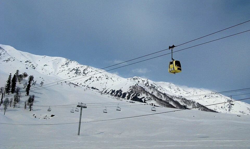
The Gulmarg Gondola is a cable-car system connecting Gulmarg with higher terrain on the Apharwat slopes. Its stages are commonly described through the Gulmarg–Kongdoori and onward upper-mountain sections. The cable car, ski terrain and settlement are different subjects, even though they are often encountered together in a visitor itinerary.[1]
Transport up the slope
The Jammu and Kashmir Cable Car Corporation operates the system and publishes its current booking and operational information. A ticket for a particular stage does not by itself provide access to every walking or skiing route beyond a station. The network of cable transport and the conditions of surrounding mountain ground must be considered separately.[2]
At a gondola station, passengers meet machinery, cabins and an organised boarding process. The system follows a defined alignment, while the view opens onto a wider landscape. A photograph of a cabin passing above forest does not establish the operating status or weather at the upper station on another date.
A mountain destination with changing conditions
The upper terrain is significantly different from the settlement below. Snow cover, visibility and permitted activities can change with conditions. Descriptions promoting the cable car as among the “highest” should specify their measurements and comparison set; its local importance can be understood without repeating an unqualified global ranking.
Visitors should use the operator's current notices for stage availability, booking and procedures. This entry avoids fixed ticket prices and opening hours, which can become stale while the infrastructure remains in place. Map directions to a station are not a route assessment for independent travel across adjoining slopes.
Read the Gulmarg entry for the settlement and recreation setting, Ice Hockey in Ladakh for a different winter-sport environment, and Thajiwas for another mountain landscape where snow, ice and access must be distinguished. The marker locates the gondola's regional setting, not a verified route from every accommodation to an open boarding gate.
Photograph and map record
Photograph: Arup1981 via Wikimedia Commons. Licence: CC BY-SA 4.0. Recorded capture date: 2013-03-11 09:59:41. Resized and converted to WebP; scene content unchanged. This is a dated view, not confirmation of the site’s present appearance.

Map marker: 34.04527778, 74.38444444. Representative source-record location, not a surveyed boundary or verified visitor entrance. Confirm actual access and accessibility locally. View location on OpenStreetMap · View Google Maps · Google directions · OpenStreetMap directions.
Research checked: 14 October 2026. For a visit, confirm current access, transport and opening information with the relevant authorities. This encyclopedia profile provides geographical and historical context.
Sources & references
[1] Gulmarg Gondola — secondary historical/geographical overview
https://en.wikipedia.org/wiki/Gulmarg_Gondola ↗
[2] Jammu and Kashmir Cable Car Corporation: operator and current information
https://www.jammukashmircablecar.com/ ↗
Photograph and licence
https://commons.wikimedia.org/wiki/File:Gulmarg_gondola.JPG ↗
Related reading
Baramulla Railway Station: Rail and Northern Kashmir
Baramulla railway station serves the northern Kashmir town and its surroundings. The district administration describes the railway connection as part
Bhajan Sopori: Santoor, Composition and Kashmir’s Musical Traditions
Bhajan Sopori was a santoor player, composer, musicologist and teacher associated with Kashmir’s musical life. He lived from 1948 to 2022. His biograp
Gulmarg: Meadow, Resort History and Winter Sports
A connected profile of Gulmarg’s upland meadow, historical patronage, recreational landscape and winter sports.