
Khilanmarg: Meadow and Mountain Setting near Gulmarg
Khilanmarg is a meadow and mountain setting near Gulmarg in Baramulla district. Published accounts connect it with views across the surrounding ranges and with the higher slopes above the Gulmarg area. It is a distinct landscape name rather than an alternative spelling of Gulmarg town, and its location should not be inferred from any generic photograph of snow in Gulmarg.
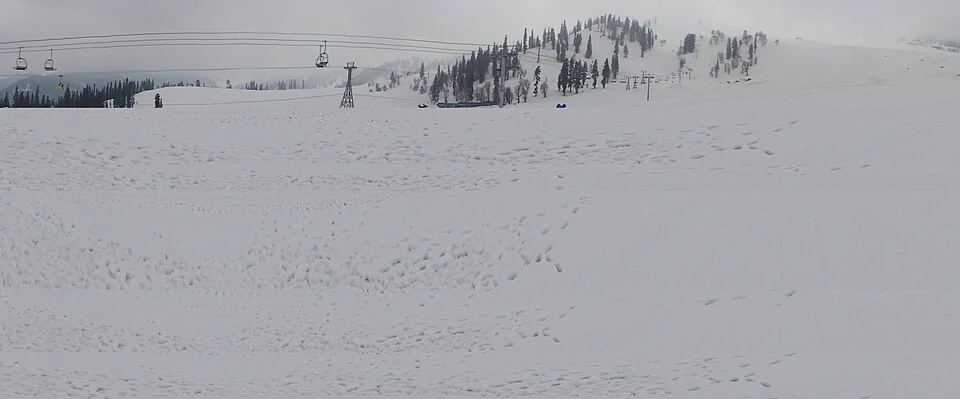
Khilanmarg is a meadow and mountain setting near Gulmarg in Baramulla district. Published accounts connect it with views across the surrounding ranges and with the higher slopes above the Gulmarg area. It is a distinct landscape name rather than an alternative spelling of Gulmarg town, and its location should not be inferred from any generic photograph of snow in Gulmarg. [1]
A meadow above a gateway
Accounts describe an ascent from Gulmarg towards Khilanmarg. This relationship places the meadow in a vertical landscape: a relatively short horizontal separation can involve substantial climbing. An encyclopedia’s general marker cannot replace a route description that identifies the actual approach and current conditions. [1]
The term meadow emphasizes open ground and vegetation, while a winter photograph may show the same kind of landscape under snow. Seasonal appearance and the identity of a named place are different questions. A caption should preserve the source’s location rather than identify a meadow by appearance alone.
Views and terrain
Mountain viewpoints can connect distant peaks and lower valleys within one image. Visibility varies with weather, light and the camera’s position, so a list of possible distant views is not a promise about what every visitor will see. Identifying a peak requires more evidence than the fact that a snowy summit appears on the horizon.
Similarly, a broad snow slope is not automatically a designated ski route. Recreational descriptions need the exact area and current operator or local guidance. Terrain visible in a photograph cannot establish permission, supervision or suitability for a particular activity.
Connections with Gulmarg
Read this entry beside Gulmarg and Tangmarg to distinguish the mountain destination, its lower road gateway and nearby meadow terrain. The map uses a clearly labelled Gulmarg-side context marker where an exact Khilanmarg visitor approach has not been independently verified. The selected photograph retains its actual source location and is identified as contextual when appropriate. This preserves the landscape relationship without inventing a trailhead or treating a generic snowy scene as precise documentary evidence. Current access and walking arrangements should be checked locally for the intended route.
Image and map record
Image: Nitin Ticku via Wikimedia Commons. Licence: CC BY-SA 3.0. Recorded capture date: 2013-03-28 12:18:21. Resized and converted to WebP; image content unchanged. This is a dated view, not confirmation of the site’s present appearance.
Map marker: 34.05, 74.38. Gulmarg-side regional context only, not a verified Khilanmarg meadow coordinate or walking approach. View location on OpenStreetMap · View Google Maps · Google directions · OpenStreetMap directions.
Research checked: 15 October 2026. For a visit, confirm current access, transport and opening information with the relevant authorities. This encyclopedia profile provides geographical and historical context.
Sources & references
[1] Wikipedia: Khilanmarg (secondary overview)
https://en.wikipedia.org/wiki/Khilanmarg ↗
Image and licence
https://commons.wikimedia.org/wiki/File:Snow_in_Gulmarg,_Kashmir.jpg ↗
Related reading
Baglihar: Hydropower and the Chenab at Chanderkote
Baglihar is a hydroelectric project on the Chenab at Chanderkote in Ramban district. Its dam, reservoir and generating works form an engineered landsc
Baramulla Railway Station: Rail and Northern Kashmir
Baramulla railway station serves the northern Kashmir town and its surroundings. The district administration describes the railway connection as part
Betaab Valley: Film-associated Landscape near Pahalgam
Betaab Valley is a visitor landscape near Pahalgam in Anantnag district. It is also associated with the older names Hajan, Hagan or Hagoon in publishe