
Betaab Valley: Film-associated Landscape near Pahalgam
Betaab Valley is a visitor landscape near Pahalgam in Anantnag district. It is also associated with the older names Hajan, Hagan or Hagoon in published accounts. Its familiar tourism name comes from the film Betaab, released in 1983, linking the place’s public identity with cinema as well as its mountain and river setting.
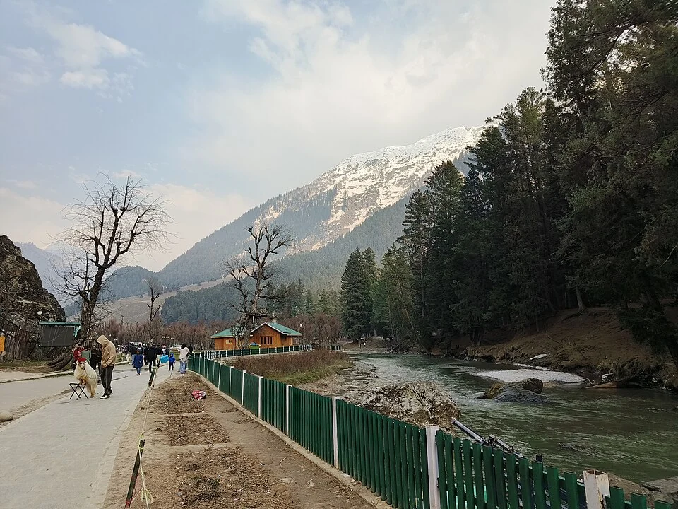
Betaab Valley is a visitor landscape near Pahalgam in Anantnag district. It is also associated with the older names Hajan, Hagan or Hagoon in published accounts. Its familiar tourism name comes from the film Betaab, released in 1983, linking the place’s public identity with cinema as well as its mountain and river setting. [1]
A landscape with a film association
Official tourism material connects the valley with the film and describes its position along the Pahalgam–Chandanwari side of the landscape. That association explains the modern name; it does not mean the valley was created for the film or that every visible structure existed during filming. [2]
Cinema can change how a place is recognized by people who have never visited it. A name used in tourism then becomes part of the location’s public history. The earlier place-name and the later popular label can coexist rather than requiring one to be dismissed as incorrect.
River, meadow and mountain views
The setting is often photographed through the contrast between open grass, water and surrounding slopes. These elements belong to a working physical landscape as well as a composed scenic view. An image’s colour and light depend on season and camera conditions, not solely on an unchanging property of the place.
A valley name covers a broader area than an entrance gate or a particular riverbank. Directions to the general coordinate therefore do not certify the exact visitor approach, opening arrangements or permission to enter every adjoining section. These details belong to current local management information.
Reading neighbouring places
Compare Betaab Valley with Aru, Pahalgam and Chandanwari. They are associated in visitor itineraries but represent separate locations with different roles. One may be a village, another a named landscape and another a mountain approach. The selected photograph identifies its source-recorded view of Betaab Valley and retains the capture date. The map is orientation rather than a surveyed visitor entrance. Reading the film association alongside physical geography helps explain why the valley has a recognizable name without reducing its history to a movie scene or inventing a uniform set of present-day visitor services.
Image and map record
Image: ThePoeticFrame via Wikimedia Commons. Licence: CC BY-SA 4.0. Recorded capture date: 2 April 2025 (according to Exif data). Resized and converted to WebP; image content unchanged. This is a dated view, not confirmation of the site’s present appearance.
Map marker: 34.05041, 75.36381. Source-recorded orientation point, not a surveyed boundary, verified visitor entrance, campsite or present access guarantee. View location on OpenStreetMap · View Google Maps · Google directions · OpenStreetMap directions.
Research checked: 15 October 2026. For a visit, confirm current access, transport and opening information with the relevant authorities. This encyclopedia profile provides geographical and historical context.
Sources & references
[1] Wikipedia: Betaab Valley (secondary overview)
https://en.wikipedia.org/wiki/Betaab_Valley ↗
[2] Incredible India: Betaab Valley and film association
Image and licence
https://commons.wikimedia.org/wiki/File:Betaab_Valley,_Pahalgam,_Kashmir.jpg ↗
Related reading
Achabal Garden: Spring-fed Terraces and Mughal Design
Achabal Garden is a Mughal garden in Anantnag district, arranged around a spring at the foot of a hill.
Anantnag Railway Station: Rail Access in Southern Kashmir
Anantnag railway station is a rail access point for southern Kashmir. It serves the Anantnag area within the Kashmir Valley corridor and is identified
Anantnag: Town, Springs and Southern Kashmir
Anantnag is a major town and district headquarters in southern Kashmir. The name also refers to the surrounding district, so town history and district