
Tangmarg: Town and Gateway towards Gulmarg
Tangmarg is a town in Baramulla district associated with the road approach towards Gulmarg. It is a settlement in its own right as well as a gateway reference in travel accounts. Keeping those roles distinct helps explain why its name appears in both local addresses and visitor itineraries without making it identical with the higher Gulmarg landscape.
Tangmarg is a town in Baramulla district associated with the road approach towards Gulmarg. It is a settlement in its own right as well as a gateway reference in travel accounts. Keeping those roles distinct helps explain why its name appears in both local addresses and visitor itineraries without making it identical with the higher Gulmarg landscape. [1]
Town and mountain gateway
Published descriptions connect Tangmarg with nearby places including Gulmarg, Drung and the Baba Reshi area. These names provide geographical relationships, not a single combined destination. A traveller seeking one site should identify its own location rather than assume that the general Tangmarg coordinate marks every attraction nearby. [1]
A gateway town can connect everyday local journeys with the movement of visitors towards a mountain destination. Shops, homes and services belong to the settlement’s life independently of the tourism route. This is why a town profile should retain more than a list of excursions.
Road landscapes and photographs
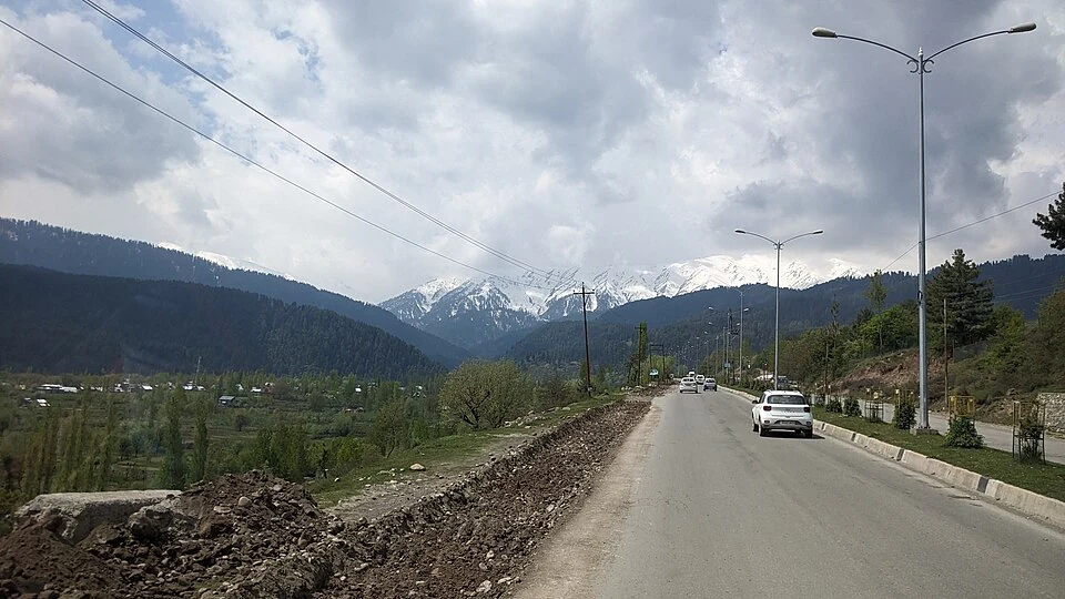
The accompanying image is captioned according to its actual source location. A photograph taken along the Srinagar–Gulmarg road can illustrate the approach corridor without being labelled the centre of Tangmarg unless that identification is supported. The camera’s position and the broader route name are different pieces of information.
Snow and weather can change the appearance of the road setting. A clear road in a dated picture does not establish present conditions or the equipment needed for another journey. Conversely, a winter scene should not be treated as proof that the town has the same appearance in every season.
Regional connections
Read Tangmarg with Gulmarg, Khilanmarg and Baba Reshi to compare a town, a meadow landscape and a religious site. Each entry needs its own image and map record. The coordinate point provides settlement orientation, not a surveyed town boundary, transport pickup or approved mountain-road stop. Current traffic arrangements belong to the relevant local information. The gateway relationship remains useful geographical context even when travel conditions change, allowing readers to understand the sequence of places without turning the encyclopedia into an undated road itinerary.
Image and map record
Image: Vinayaraj via Wikimedia Commons. Licence: CC BY-SA 4.0. Recorded capture date: Taken on 26 April 2023, 10:57. Resized and converted to WebP; image content unchanged. This is a dated view, not confirmation of the site’s present appearance.
Map marker: 34.05916667, 74.42444444. Source-recorded orientation point, not a surveyed boundary, verified visitor entrance, campsite or present access guarantee. View location on OpenStreetMap · View Google Maps · Google directions · OpenStreetMap directions.
Research checked: 15 October 2026. For a visit, confirm current access, transport and opening information with the relevant authorities. This encyclopedia profile provides geographical and historical context.
Sources & references
[1] Wikipedia: Tangmarg (secondary overview)
https://en.wikipedia.org/wiki/Tangmarg ↗
Image and licence
https://commons.wikimedia.org/wiki/File:Srinagar_to_Gulmarg_-_vrvvkbjk2k23pxl_(179).jpg ↗
Related reading
Anantnag: Town, Springs and Southern Kashmir
Anantnag is a major town and district headquarters in southern Kashmir. The name also refers to the surrounding district, so town history and district
Aru: Village and Mountain Landscape above Pahalgam
Aru is a village and mountain visitor destination in Anantnag district, above the Pahalgam area. It is also known as Adav in Kashmiri. Meadows, settle
Baramulla Railway Station: Rail and Northern Kashmir
Baramulla railway station serves the northern Kashmir town and its surroundings. The district administration describes the railway connection as part