
Buckwheat in Ladakh: Crop, Food and Mountain Fields
Buckwheat is a seed crop used like a cereal even though it is not a grass and is not closely related to wheat. Common buckwheat belongs to the knotweed family and is classed as a pseudocereal. This botanical distinction matters in Ladakh because a familiar food or field crop need not fit the category suggested by its English name.
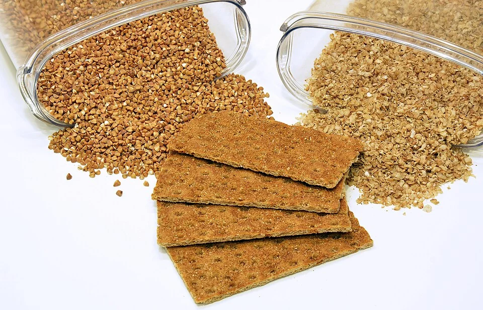
Buckwheat is a seed crop used like a cereal even though it is not a grass and is not closely related to wheat. Common buckwheat belongs to the knotweed family and is classed as a pseudocereal. This botanical distinction matters in Ladakh because a familiar food or field crop need not fit the category suggested by its English name. [1]
Cultivation in Ladakh
Published agricultural research describes buckwheat cultivation in Ladakh both as a main crop and in some settings after barley. Its place in a short growing season depends on local agricultural practice. Such a study documents its research setting and period; it does not establish a single planting schedule for all valleys or elevations. [2]
The crop can be understood through its relationship with other cultivated plants. A farm may allocate fields and labour among several crops rather than organizing its entire livelihood around one species. Reading buckwheat beside barley helps explain crop choice without assuming that the two are botanically equivalent.
Seed, plant and food
Buckwheat’s grain-like seeds provide the link between cultivation and food preparation. A flowering plant photograph explains its appearance in the field; a picture of seeds or flour explains a later stage. Captions should identify which stage is shown, especially when an illustrative image was recorded outside Ladakh.
The term pseudocereal concerns botanical classification and food use. It does not imply that a crop is false, inferior or merely an imitation of another food. The category allows readers to distinguish how a seed is used from the plant family to which it belongs.
A regional agricultural record
The Nubra map marker is a labelled regional context point, not proof that the crop originated there or that every nearby field contains buckwheat. Likewise, a general species illustration is not documentary evidence of a particular Ladakh harvest. Compare this entry with barley, apricots and local settlement profiles to connect crop diversity with village landscapes. Production quantities, planting recommendations and seed choices require their own dated agricultural evidence rather than an inference from a photograph or a broad description of mountain farming.
Image and map record
Image: Andrey Korzun via Wikimedia Commons. Licence: CC BY-SA 4.0. Recorded capture date: 2015-07-26 23:33:51. Resized and converted to WebP; image content unchanged. This is a dated view, not confirmation of the site’s present appearance.
Map marker: 34.55, 77.56. Labelled regional/locality context marker; not a verified public entrance, pickup point, birthplace, residence, venue, trailhead, crop boundary or visitor route. View location on OpenStreetMap · View Google Maps · Google directions · OpenStreetMap directions.
Research checked: 15 October 2026. For a visit, confirm current access, transport and opening information with the relevant authorities. This encyclopedia profile provides geographical and historical context.
Sources & references
[1] Wikipedia: Buckwheat (secondary overview)
https://en.wikipedia.org/wiki/Buckwheat ↗
[2] ICAR-published research: buckwheat cultivation in Ladakh, 2022
https://epubs.icar.org.in/index.php/ijee/article/view/122628 ↗
Image and licence
https://commons.wikimedia.org/wiki/File:Buckwheat_and_products_from_it_01.jpg ↗
Related reading
Barley in Ladakh: Cultivation and Regional Food Traditions
Barley is a cereal grass cultivated for its grain. In Ladakh it forms part of the relationship between farming, household food and a limited mountain
Diskit Monastery: Gelug Heritage and the Nubra Valley
Nubra’s Gelug monastery, hillside architecture, community life and the newer district classification.
Hunder: Settlement and Sand-dune Landscape in Nubra
Hunder, also written Hundar, is a village in Nubra known for a landscape combining settlement, cultivated ground and nearby sand dunes.