
Likir Monastery: Gelug Tradition and a Village Valley
Likir is a Buddhist monastery associated with the Gelug tradition, in a village valley west of Leh.
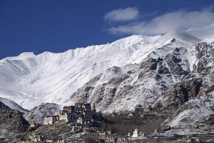
Likir is a Buddhist monastery associated with the Gelug tradition, in a village valley west of Leh. The complex brings together assembly spaces, religious objects and later additions in a landscape of settlement and cultivated land. Its commonly repeated founding traditions reach back to the eleventh century, but the institution's history includes rebuilding and changes of affiliation. The visible complex should therefore not be assigned one age as though it were a single unchanged building.[1]
An institution that developed over time
A prominent feature is the large outdoor Maitreya statue, a relatively recent addition compared with the monastery's early history. It represents the future Buddha and is distinct from the older interior spaces. Describing the statue and the monastic institution separately helps avoid a familiar mistake: using the date of a modern landmark as the founding date of the whole site.[1]
The official district culture account identifies Likir among Ladakh's religious centres and notes the appeal of its festival performances. This places the monastery within a living cultural landscape. Festival activity, however, should not be presumed to occur whenever a traveller visits, and an annual institution should not be reduced to a performance for tourists.[2]
The valley setting offers another way to understand the site. A monastery's location is related to the surrounding community and routes, not only to the shape of its buildings. Fields, houses and religious structures may appear together in a photograph; keeping their functions distinct provides a richer description than labelling the entire view “the monastery.”
Connections through art and administration
Alchi is connected with Likir in its later management history. That institutional connection is useful, but the two places retain different architecture and artistic programmes. Alchi's painted temples and Likir's hillside complex should be examined on their own terms. Lamayuru supplies another comparison from the western Ladakh corridor.
This article uses the current Sham district filter for Likir, following the notified 2026 village allocation. Older references to Leh district remain understandable as historical administrative descriptions. A representative monastery coordinate assists orientation; it does not certify a step-free approach, visitor entrance or access to individual rooms. Such details need a current site-specific check, especially when planning a visit for someone with mobility needs.
Photograph and map record
Photograph: No machine-readable author provided. Morrisjm assumed (based on copyright claims). via Wikimedia Commons. Licence: CC BY 2.5. Recorded capture date: Date not recorded. Resized and converted to WebP; scene content unchanged. This is a dated view, not confirmation of the site’s present appearance.

Map marker: 34.27666667, 77.215. Representative location from the secondary geographical record, not a surveyed boundary or verified visitor entrance. View location on OpenStreetMap · View Google Maps · Google directions · OpenStreetMap directions.
Research checked: 14 October 2026. For a visit, confirm current access, transport and opening information with the relevant authorities. This encyclopedia profile provides geographical and historical context.
Sources & references
[1] Likir Monastery — secondary historical/geographical overview
https://en.wikipedia.org/wiki/Likir_Monastery ↗
[2] Leh district: culture, heritage and monastery festivals
https://leh.nic.in/tourism/culture-heritage/ ↗
Photograph and licence
Related reading
Alchi: Painted Temples and the Art of Western Himalayan Buddhism
Alchi is a Buddhist temple complex in the lower Indus valley, known especially for its painted interiors, sculpture and carved woodwork.
Diskit Monastery: Gelug Heritage and the Nubra Valley
Nubra’s Gelug monastery, hillside architecture, community life and the newer district classification.
Fotu La: A High Pass on Ladakh’s Western Road Corridor
Fotu La, also written Fatu La, is a mountain pass on the Srinagar–Leh road corridor in western Ladakh. It lies near the approach to Lamayuru and forms