
Pulwama: Town and District Headquarters in Kashmir
Pulwama is a town and the headquarters of Pulwama district in Kashmir. The town’s name is also used for the wider administrative area, making it important to distinguish an urban-place statement from a district-wide one. An encyclopedia profile should not transfer the location of every district crop, temple or historic site to the headquarters coordinate.
Pulwama is a town and the headquarters of Pulwama district in Kashmir. The town’s name is also used for the wider administrative area, making it important to distinguish an urban-place statement from a district-wide one. An encyclopedia profile should not transfer the location of every district crop, temple or historic site to the headquarters coordinate. [1]
Settlement and administrative role
The district administration’s account discusses earlier forms of the settlement name and the joining of hamlets into a town. Such a local history should retain its status as the administration’s account rather than become an unsupported reconstruction of every stage of settlement. Names, institutional changes and physical growth require different kinds of evidence. [2]
A headquarters links the town with public services used across a larger area. People may travel to offices there from settlements elsewhere in the district. That relationship explains administrative importance without implying that the town and district have identical boundaries or populations.
Town within an agricultural district
Pulwama’s wider district includes agricultural landscapes and places associated with saffron and other crops. Pampore, Awantipora and Tral are separate settlement names within regional accounts. Their identities should be preserved instead of describing them as streets or attractions inside Pulwama town.
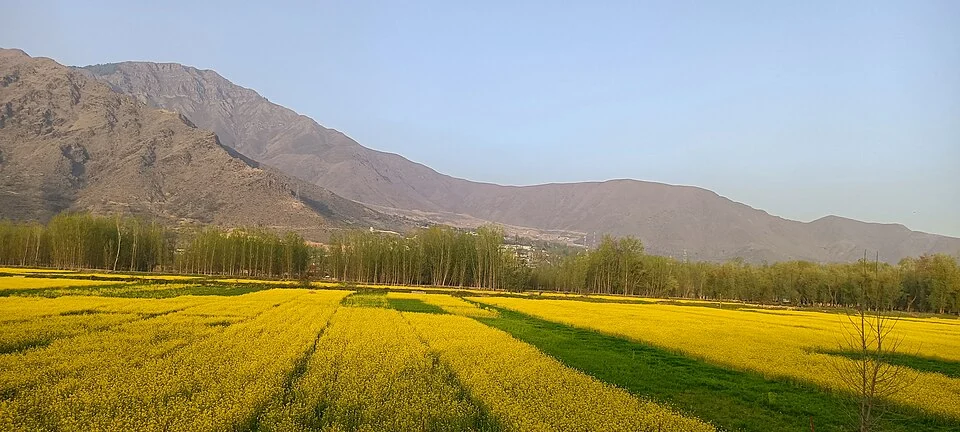
A photograph from another named part of the district can illustrate regional context only when clearly captioned. The image accompanying this profile therefore identifies its actual source location. It is not presented as a town-centre view if it records fields or heritage elsewhere in the district.
Connections and records
Read this entry with Pampore, rice farming and district heritage profiles to distinguish the headquarters from the surrounding production and cultural landscape. Census statistics must retain both their year and geographical unit; district totals cannot be substituted for town figures. The map marker gives urban orientation rather than a surveyed municipal boundary or a verified entrance to an office. Current institutional addresses supply practical directions. Keeping settlement history, district identity and neighbouring places separate creates a clearer account of Pulwama than treating the familiar name as one undifferentiated point on a map.
Image and map record
Image: TheAutumnal via Wikimedia Commons. Licence: CC BY-SA 4.0. Recorded capture date: 2022-03-27 17:59:31. Resized and converted to WebP; image content unchanged. This is a dated view, not confirmation of the site’s present appearance.
Map marker: 33.8741, 74.9001. Source-recorded orientation point, not a surveyed boundary, verified visitor entrance, campsite or present access guarantee. View location on OpenStreetMap · View Google Maps · Google directions · OpenStreetMap directions.
Research checked: 15 October 2026. For a visit, confirm current access, transport and opening information with the relevant authorities. This encyclopedia profile provides geographical and historical context.
Sources & references
[1] Wikipedia: Pulwama (secondary overview)
https://en.wikipedia.org/wiki/Pulwama ↗
[2] Pulwama administration: town names and district account
https://pulwama.gov.in/about-district/ ↗
Image and licence
https://commons.wikimedia.org/wiki/File:Mustard_Fields,_NH-44,_Awantipora,_J%26K.jpg ↗
Related reading
Anantnag: Town, Springs and Southern Kashmir
Anantnag is a major town and district headquarters in southern Kashmir. The name also refers to the surrounding district, so town history and district
Aru: Village and Mountain Landscape above Pahalgam
Aru is a village and mountain visitor destination in Anantnag district, above the Pahalgam area. It is also known as Adav in Kashmiri. Meadows, settle

Awantipora Temples: Avantivarman and the Archaeology of a Royal Town
The distinction between Avantiswami and Avantishwara and their association with Avantivarman’s royal town.