
Pampore: Town and Saffron-growing Landscape
Pampore, also known as Pampar or Panpar in Kashmiri, is a town in Pulwama district associated with Kashmir's saffron-growing landscape. It lies near the Jhelum and on the southern approach to Srinagar. The town and the surrounding cultivation area are related but should not be treated as the same geographical unit.
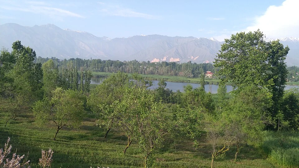
Pampore, also known as Pampar or Panpar in Kashmiri, is a town in Pulwama district associated with Kashmir's saffron-growing landscape. It lies near the Jhelum and on the southern approach to Srinagar. The town and the surrounding cultivation area are related but should not be treated as the same geographical unit.[1]
Town and karewa fields
The Pulwama administration connects saffron production with the karewa lands around Pampore and neighbouring areas. Karewa ground is central to the crop's regional setting. A town photograph and a close image of saffron flowers show different parts of that relationship.[2]
CSIR–Indian Institute of Integrative Medicine identifies Pampore within its account of saffron production in Jammu and Kashmir. Such a research-institution source supplies agricultural context, while annual area and yield figures need a named reference year before they are compared.[3]
Production and trade
Saffron's journey includes growing, harvesting, separating the flower's stigmas, drying and marketing. A place associated with the crop can contain fields, households and trade institutions without all of those activities occurring at one address.
A dated Pulwama administration record describes the Spice Park at Dussu, Pampore. That record identifies a specific trade-related institution, distinct from the town as a whole. Its current services and operating arrangements need present institutional information.[4]
Seasonal flower photographs are useful for illustrating cultivation, but they do not guarantee that a visitor will find the same stage of flowering on a fixed day every year. Weather, field conditions and the particular growing plot affect what is visible.
Read Kashmir Saffron, Awantipora Temples and Jhelum River for crop, heritage and watercourse context. Habba Khatoon supplies a separate literary association with southern Kashmir. The marker locates Pampore town rather than a specific saffron field, trade-centre entrance or the boundary of all cultivation. Access to a working field requires its own local arrangement.
Image and map record
Image: Ashfaq ahanger via Wikimedia Commons. Licence: CC BY-SA 4.0. Recorded capture date: 2017-05-26 17:39:53. Resized and converted to WebP; image content unchanged. This is a dated view, not confirmation of the site’s present appearance.

Map marker: 34.02, 74.93. Source-recorded location for orientation; not a surveyed boundary, verified public entrance, current access guarantee or authorised stopping point. View location on OpenStreetMap · View Google Maps · Google directions · OpenStreetMap directions.
Research checked: 14 October 2026. For a visit, confirm current access, transport and opening information with the relevant authorities. This encyclopedia profile provides geographical and historical context.
Sources & references
[1] Reference overview: Pampore
https://en.wikipedia.org/wiki/Pampore ↗
[2] Pulwama administration: Pampore and saffron cultivation
https://pulwama.gov.in/history/ ↗
[3] CSIR–IIIM: saffron production
https://iiim.res.in/saffron-production/ ↗
[4] Pulwama administration: Spice Park at Dussu, 2019
https://pulwama.gov.in/ddc-pulwama-visits-spice-park-pampore/ ↗
Image and licence
https://commons.wikimedia.org/wiki/File:Pampore,_Jammu_and_Kashmir.jpg ↗
Related reading
Anantnag: Town, Springs and Southern Kashmir
Anantnag is a major town and district headquarters in southern Kashmir. The name also refers to the surrounding district, so town history and district
Aru: Village and Mountain Landscape above Pahalgam
Aru is a village and mountain visitor destination in Anantnag district, above the Pahalgam area. It is also known as Adav in Kashmiri. Meadows, settle

Awantipora Temples: Avantivarman and the Archaeology of a Royal Town
The distinction between Avantiswami and Avantishwara and their association with Avantivarman’s royal town.