
Rainawari: A Neighbourhood in Srinagar’s Lake-side Landscape
Rainawari is a neighbourhood of Srinagar, located in the city’s lake-side urban landscape. Its importance lies in the relationship between everyday residential life, older streets and the wider geography of the Dal basin. It is a locality within Srinagar, rather than a separate district or an alternative name for the whole old city.
Rainawari is a neighbourhood of Srinagar, located in the city’s lake-side urban landscape. Its importance lies in the relationship between everyday residential life, older streets and the wider geography of the Dal basin. It is a locality within Srinagar, rather than a separate district or an alternative name for the whole old city. [1]
Neighbourhood rather than a single monument
The Srinagar administration includes Rainawari in its published patwar-halqas information. This gives the name an administrative presence alongside its use in addresses and local conversation. Revenue units, municipal wards and the area residents call a neighbourhood need not have identical boundaries, so a point on a map cannot define the complete locality. [2]
Rainawari is best read at street scale. A neighbourhood contains homes, shops, places of worship, institutions and routes used for ordinary journeys. A visitor who photographs only an architectural landmark records one element of that environment. An encyclopedia entry should keep the surrounding community visible, rather than reducing its name to a sightseeing stop.
Lake-side Srinagar and historical views
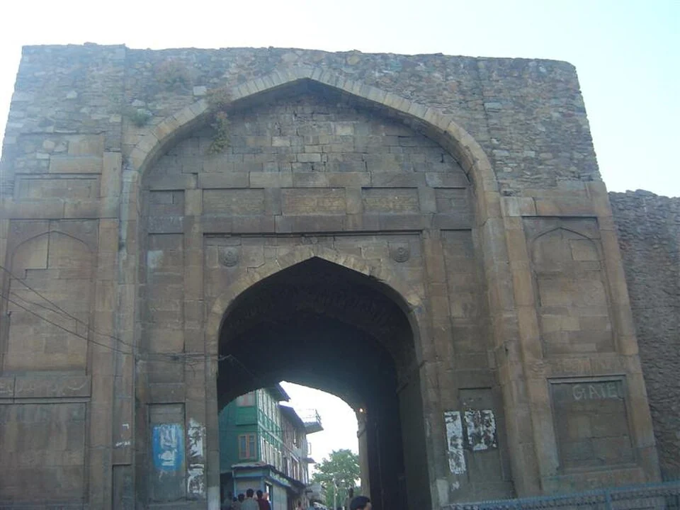
The accompanying Kathi Darwaza photograph records a gateway associated with the Rainawari setting. It is a dated image of a particular structure, not a panoramic record of every street. Gateway architecture can help explain how movement, enclosure and older urban routes shaped Srinagar, but the age of an individual wall cannot automatically be applied to adjacent buildings.
The relationship between water and settlement is also central to understanding this part of the city. The Dal basin, connected waterways and nearby urban areas belong to a larger landscape. A street address and a lake viewpoint answer different geographical questions. Neither establishes that every household shares the same occupation or access to the waterfront.
Reading the area in context
Compare Rainawari with Nowhatta, Zaina Kadal and Dal Lake to distinguish residential geography, bridge-based urban connections and lake ecology. Keep neighbourhood names attached to verified locations when adding schools, shrines or public services. Such cross-references make the city intelligible through relationships while preserving the identity of individual places.
Image and map record
Image: Oniongas via Wikimedia Commons. Licence: Public domain. Recorded capture date: Date not recorded. Resized and converted to WebP; image content unchanged. This is a dated view, not confirmation of the site’s present appearance.
Map marker: 34.09777778, 74.82277778. Source-recorded orientation point, not a surveyed boundary, verified visitor entrance, campsite or present access guarantee. View location on OpenStreetMap · View Google Maps · Google directions · OpenStreetMap directions.
Research checked: 15 October 2026. For a visit, confirm current access, transport and opening information with the relevant authorities. This encyclopedia profile provides geographical and historical context.
Sources & references
[1] Wikipedia: Rainawari (secondary overview)
https://en.wikipedia.org/wiki/Rainawari ↗
[2] Srinagar administration: patwar-halqas
https://srinagar.nic.in/patwar-halqas/ ↗
Image and licence
https://commons.wikimedia.org/wiki/File:Kathi_Darwaza_rainawari.jpg ↗
https://commons.wikimedia.org/wiki/File:Kathi_Darwaza_rainawari.jpg#Licensing ↗
Related reading
Aali Masjid: Open Ground and a Historic Srinagar Mosque
Aali Masjid, also written Ali Masjid, is a historic mosque in Srinagar's Eidgah area.

Agha Shahid Ali: Poetry, Memory and Kashmir
Agha Shahid Ali was a Kashmiri-American poet who lived from 1949 to 2001. Born in New Delhi and raised in a family associated with Kashmir, he develop
Amar Singh College: Education, Campus Heritage and Institutional Change
The growth of an educational institution from a technical institute, with campus conservation and academic resources.