
Nowhatta: Neighbourhood and Mosque Setting in Old Srinagar
Nowhatta, also rendered Navyut in Kashmiri, is a neighbourhood in Srinagar’s older urban area. It is especially associated with the setting of Jamia Masjid. The neighbourhood and the mosque are related but distinct subjects: one concerns an inhabited urban area, while the other concerns a particular religious and architectural complex.
Nowhatta, also rendered Navyut in Kashmiri, is a neighbourhood in Srinagar’s older urban area. It is especially associated with the setting of Jamia Masjid. The neighbourhood and the mosque are related but distinct subjects: one concerns an inhabited urban area, while the other concerns a particular religious and architectural complex. [1]
An inhabited heritage setting
Nowhatta appears in Srinagar’s published patwar-halqas information, providing an administrative reference for the locality’s name. Such listings should not be treated as a complete guide to municipal boundaries or to the way residents describe their streets. Administrative geography and everyday neighbourhood usage can overlap without being identical. [2]
A large mosque influences surrounding movement through entrances, gathering spaces and adjoining streets. That relationship does not mean the neighbourhood exists only during worship or that every nearby building belongs to the religious complex. Residential, commercial and community uses also contribute to the character of an urban place.
What an image can show
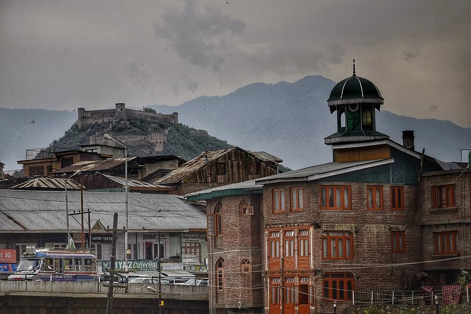
The selected photograph looks from the Jamia Masjid Chowk setting towards Hari Parbat. It links a foreground public space with a distant landmark. The two locations are not thereby placed inside the same compound. Reading the caption carefully avoids confusing the position of the photographer with the position of the object visible on the skyline.
Historic urban views are particularly useful for comparing scale. Rooflines, street approaches and distant slopes can show how a monument sits among ordinary buildings. They are less reliable as a present-day service guide: a photographed shopfront or open route may have changed since the image was recorded.
Neighbourhood and monument records
For an architectural account, use the separate Jamia Masjid entry. For broader city geography, compare Rainawari, Zaina Kadal and the Jhelum. These links allow a reader to move between a religious site, a neighbourhood and the network of river crossings. The marker in this entry represents the Nowhatta setting rather than a surveyed boundary or a guaranteed visitor entrance. When adding smaller shrines, schools or public facilities, attach their own sourced address instead of assuming that the general neighbourhood point is sufficient.
Image and map record
Image: Parshati via Wikimedia Commons. Licence: CC BY-SA 4.0. Recorded capture date: 2017-04-25. Resized and converted to WebP; image content unchanged. This is a dated view, not confirmation of the site’s present appearance.
Map marker: 34.1, 74.81. Source-recorded orientation point, not a surveyed boundary, verified visitor entrance, campsite or present access guarantee. View location on OpenStreetMap · View Google Maps · Google directions · OpenStreetMap directions.
Research checked: 15 October 2026. For a visit, confirm current access, transport and opening information with the relevant authorities. This encyclopedia profile provides geographical and historical context.
Sources & references
[1] Wikipedia: Nowhatta (secondary overview)
https://en.wikipedia.org/wiki/Nowhatta ↗
[2] Srinagar administration: patwar-halqas
https://srinagar.nic.in/patwar-halqas/ ↗
Image and licence
https://commons.wikimedia.org/wiki/File:S-JK-6_Hari_Parbat_from_Jamia_Masjid_Chowk_at_Nowhatta.jpg ↗
Related reading
Aali Masjid: Open Ground and a Historic Srinagar Mosque
Aali Masjid, also written Ali Masjid, is a historic mosque in Srinagar's Eidgah area.

Agha Shahid Ali: Poetry, Memory and Kashmir
Agha Shahid Ali was a Kashmiri-American poet who lived from 1949 to 2001. Born in New Delhi and raised in a family associated with Kashmir, he develop
Amar Singh College: Education, Campus Heritage and Institutional Change
The growth of an educational institution from a technical institute, with campus conservation and academic resources.