
Zaina Kadal: Bridge, Neighbourhood and Old Srinagar
Zaina Kadal is a historic bridge name and an urban reference point in Srinagar. The bridge crosses the Jhelum, placing it within the sequence of crossings that helped connect the city’s riverbank settlements. Historical accounts associate its foundation with Sultan Zain-ul-Abidin in the fifteenth century. A long history of repair means that origin should be distinguished from the age of visible fabric.
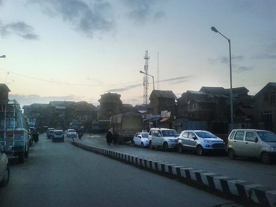
Zaina Kadal is a historic bridge name and an urban reference point in Srinagar. The bridge crosses the Jhelum, placing it within the sequence of crossings that helped connect the city’s riverbank settlements. Historical accounts associate its foundation with Sultan Zain-ul-Abidin in the fifteenth century. A long history of repair means that origin should be distinguished from the age of visible fabric. [1]
Bridge and neighbourhood
The surrounding old-city setting links the crossing with streets, commerce and craft activity. Srinagar’s published local-craft information identifies Zaina Kadal within its urban artisan geography. A bridge therefore belongs to a wider working neighbourhood: people cross it to reach homes, workshops and markets, as well as to see historic architecture. [2]
A bridge name often extends into directions and addresses nearby. That everyday usage does not make the whole area a single architectural property. Likewise, a photograph captioned Zaina Kadal may show the surrounding riverbank rather than the bridge deck. Identifying the camera’s subject is necessary before drawing conclusions about materials or construction.
Water, timber and repair
Timber bridges are particularly dependent on maintenance. Water levels, weathering and changes in traffic can require replacement of components while a crossing retains its established name. The meaningful historical question is therefore how a crossing persisted through rebuilding, rather than whether every piece of its present structure is medieval.
The Jhelum is both the physical obstacle a bridge spans and the organizing line of older Srinagar. A crossing allows movement between banks; nearby landing places and roads add further connections. Reading Zaina Kadal alongside other river bridges explains the city more clearly than viewing each crossing as an isolated attraction.
Historical interpretation
The bridge’s royal association can be compared with accounts of Zain-ul-Abidin and the city’s wider heritage. Architectural resemblance alone cannot date a structure, and a convenient modern approach should not be mistaken for an original medieval route. The map marker gives orientation near the crossing. It does not establish the extent of the neighbourhood, ownership of adjoining properties or a surveyed heritage boundary.
Image and map record
Image: Owais Khursheed via Wikimedia Commons. Licence: CC BY-SA 4.0. Recorded capture date: 2015-01-22 17:48:56. Resized and converted to WebP; image content unchanged. This is a dated view, not confirmation of the site’s present appearance.
Map marker: 34.0938, 74.8065. Source-recorded orientation point, not a surveyed boundary, verified visitor entrance, campsite or present access guarantee. View location on OpenStreetMap · View Google Maps · Google directions · OpenStreetMap directions.
Research checked: 15 October 2026. For a visit, confirm current access, transport and opening information with the relevant authorities. This encyclopedia profile provides geographical and historical context.
Sources & references
[1] Wikipedia: Zaina Kadal (secondary overview)
https://en.wikipedia.org/wiki/Zaina_Kadal ↗
[2] Srinagar administration: local craft geography
https://srinagar.nic.in/local-craft/ ↗
Image and licence
https://commons.wikimedia.org/wiki/File:Downtown_(Zaina_Kadal).jpg ↗
Related reading
Aali Masjid: Open Ground and a Historic Srinagar Mosque
Aali Masjid, also written Ali Masjid, is a historic mosque in Srinagar's Eidgah area.

Agha Shahid Ali: Poetry, Memory and Kashmir
Agha Shahid Ali was a Kashmiri-American poet who lived from 1949 to 2001. Born in New Delhi and raised in a family associated with Kashmir, he develop
Amar Singh College: Education, Campus Heritage and Institutional Change
The growth of an educational institution from a technical institute, with campus conservation and academic resources.