
Shopian: Town, Orchards and the Southern Valley
Shopian, also written Shupiyan, is a town in southern Kashmir and the headquarters of Shopian district. Its regional identity is closely associated with orchards and with the route across the Pir Panjal known as the Mughal Road. The town, district and road corridor are connected subjects, but they should retain separate geographical records.
Shopian, also written Shupiyan, is a town in southern Kashmir and the headquarters of Shopian district. Its regional identity is closely associated with orchards and with the route across the Pir Panjal known as the Mughal Road. The town, district and road corridor are connected subjects, but they should retain separate geographical records. [1]
A town on a historical corridor
The district administration describes Shopian’s historical importance in relation to the imperial route. Its Mughal Road material links the town with journeys made towards Kashmir from the other side of the mountains. This is historical context, not evidence that every part of the modern road reproduces an unchanged old alignment. [2]
Road histories often combine older movement with later reconstruction. The continuity of a route name does not establish that the present surface, bridges or traffic arrangements are as old as the journeys associated with it. Dating the different layers is necessary for a clear account.
Orchards and urban life
An orchard district and its headquarters have different roles in a production system. Fruit cultivation occurs in agricultural land, while a town can support trade, services and administrative work. A photograph of trees therefore illustrates agriculture rather than proving that every street in the town is an orchard.
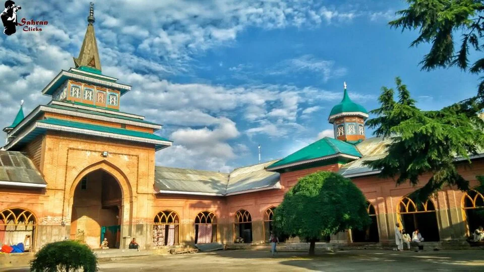
The accompanying Jamia Masjid photograph records a specific building in Shopian. It provides an urban architectural reference while retaining the identity of the religious site. The image should not be presented as a complete view of the whole town or as evidence for current visitor access.
Connections across southern Kashmir
Read Shopian with orchard profiles and the Mughal Road-related landscape entries to connect cultivation, town life and mountain movement. Claims about production rankings or the proportion of residents employed in a sector need dated statistical evidence; they are not inferred here from the town’s familiar apple association. The map point gives town orientation rather than a municipal boundary or a verified road departure point. Current road opening and transport arrangements require separate confirmation. The historical corridor remains useful for understanding Shopian while the town’s own identity extends beyond a single route or crop.
Image and map record
Image: Sauood07 via Wikimedia Commons. Licence: CC BY-SA 4.0. Recorded capture date: 2015-08-23. Resized and converted to WebP; image content unchanged. This is a dated view, not confirmation of the site’s present appearance.
Map marker: 33.72, 74.83. Source-recorded orientation point, not a surveyed boundary, verified visitor entrance, campsite or present access guarantee. View location on OpenStreetMap · View Google Maps · Google directions · OpenStreetMap directions.
Research checked: 15 October 2026. For a visit, confirm current access, transport and opening information with the relevant authorities. This encyclopedia profile provides geographical and historical context.
Sources & references
[1] Wikipedia: Shopian (secondary overview)
https://en.wikipedia.org/wiki/Shopian ↗
[2] Shopian administration: Mughal Road
https://shopian.nic.in/tourist-place/mughal-road/ ↗
Image and licence
https://commons.wikimedia.org/wiki/File:Jamia_masjid_shopian.jpg ↗
Related reading
Anantnag: Town, Springs and Southern Kashmir
Anantnag is a major town and district headquarters in southern Kashmir. The name also refers to the surrounding district, so town history and district
Aru: Village and Mountain Landscape above Pahalgam
Aru is a village and mountain visitor destination in Anantnag district, above the Pahalgam area. It is also known as Adav in Kashmiri. Meadows, settle

Basohli: Ravi-side Town and a Centre of Pahari Painting
Basohli is a town in Kathua district, in the Jammu region, overlooking the Ravi river landscape.