
Tulail Valley: Settlements and the Kishanganga Mountain Landscape
Tulail is a mountain valley in Bandipora district, connected with the wider Gurez and Kishanganga landscape.
Tulail is a mountain valley in Bandipora district, connected with the wider Gurez and Kishanganga landscape. Its settlements and routes occupy a highland setting where the river, slopes and cultivable ground shape everyday geography. The valley name and the administrative tehsil are related concepts, but their extent should not automatically be assumed identical.[1]
Settlements within a river landscape
Reference descriptions identify Tulail in the eastern Gurez setting and connect its settlement geography with the Kishanganga river system. Villages and cultivated areas form part of the valley's identity; a description consisting only of mountain views would leave out the communities living within it.[1]
The Bandipora administration lists Tulail among its tehsils and maintains corresponding administrative records. These provide an official institutional context rather than a tourism label alone. A tehsil record does not by itself supply a walking route, a surveyed valley boundary or the opening status of a mountain road.[2]
Buildings, routes and seasons
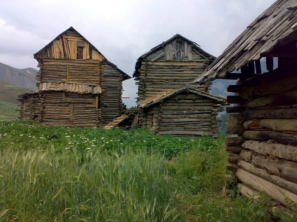
Wooden houses appear in source-identified photographs of the valley. Such images can document a local building form, while the date and location are necessary for interpreting individual structures. One photograph should not be used to claim that every village or present household has the same architecture.
Highland routes depend on conditions as well as on their line on a map. Distance, road surface and seasonal access are different questions. A regional encyclopedia can explain how places are connected without promising that a service operates on a particular day or that every marked path is suitable for an independent walk.
Read the Wular Lake entry for another Bandipora-area landscape and Lolab for a separate northern Kashmir valley. Drass adds a mountain-settlement comparison across the wider region. The representative Tulail coordinate is orientation information, not a boundary of the tehsil or an authorisation to travel through restricted ground.
Photograph and map record
Photograph: ZAHID SAMOON via Wikimedia Commons. Licence: CC BY 3.0. Recorded capture date: 2009-07-28 10:13. Resized and converted to WebP; scene content unchanged. This is a dated view, not confirmation of the site’s present appearance.

Map marker: 34.55611111, 75.05416667. Representative source-record location, not a surveyed boundary or verified visitor entrance. Confirm actual access and accessibility locally. View location on OpenStreetMap · View Google Maps · Google directions · OpenStreetMap directions.
Research checked: 14 October 2026. For a visit, confirm current access, transport and opening information with the relevant authorities. This encyclopedia profile provides geographical and historical context.
Sources & references
[1] Tulail Valley — secondary historical/geographical overview
https://en.wikipedia.org/wiki/Tulail_Valley ↗
[2] Bandipora district: Tulail tehsil
https://bandipore.nic.in/tehsil/ ↗
Photograph and licence
https://commons.wikimedia.org/wiki/File:Wooden_houses_in_Tulail.jpg ↗
Related reading
Doodhpathri: Meadow, Streams and the Budgam Uplands
Doodhpathri is a meadow destination in Budgam district's Khansahib area, in the Pir Panjal uplands.
Lolab Valley: Villages, Forests and the Lalkul Waterscape
Lolab’s stream, villages, cultivated ground and forested slopes within Kupwara district.
Wular Lake: Flood Storage, Wetland Ecology and Livelihoods
Wular as a connected Jhelum wetland, a working landscape and a conservation priority spanning Bandipora and Baramulla.