
Tyndale Biscoe School: Education and Institutional History in Srinagar
Tyndale Biscoe School is a long-established school in Srinagar's Sheikh Bagh area, near Lal Chowk.
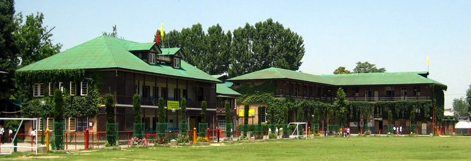
Tyndale Biscoe School is a long-established school in Srinagar's Sheikh Bagh area, near Lal Chowk. Its history is linked with Christian missionary education and with Cecil Tyndale-Biscoe, whose name it bears. The school is a particular institution within a larger city educational landscape, not a general name for every school managed by the associated society.[1]
Institution and historical setting
Reference histories trace its beginnings to 1880 and identify J. H. Knowles among its early principals. Historical accounts associate the school with physical activity and practical training alongside classroom work. Such features belong to an institutional history and should not be assumed to describe every present class or admission requirement.[1]
The Tyndale-Biscoe and Mallinson Society maintains official school and admission information, distinguishing its different institutions and locations. This is important when a family or researcher identifies a campus: the society name, school name and branch are not interchangeable.[2]
A school within Srinagar
School history can be studied through buildings, records, teaching and former pupils' recollections. Each gives a different view. An early photograph may document a campus arrangement, while a timetable identifies classroom organisation at a particular date. A prominent graduate alone cannot describe the experience of all pupils.
The central-city setting also connects the school with the changing life of Srinagar. Routes to the campus and the surrounding neighbourhood belong to contemporary urban geography, while the institution's history covers a longer period. Keeping these scales separate helps explain both the building in its present setting and the educational tradition associated with its name.
Compare Burn Hall School for another Srinagar institution and Sri Pratap College for the growth of higher education. Amar Singh College adds a separate campus history. This profile does not rank schools or replace current admission notices. The marker locates the school area; visits, appointments and access should follow the institution's current arrangements.
Photograph and map record
Photograph: Abdul Haadi via Wikimedia Commons. Licence: CC BY-SA 3.0. Recorded capture date: 7 June 2008 (according to Exif data). Resized and converted to WebP; scene content unchanged. This is a dated view, not confirmation of the site’s present appearance.

Map marker: 34.071402, 74.812234. Representative source-record location, not a surveyed boundary or verified visitor entrance. Confirm actual access and accessibility locally. View location on OpenStreetMap · View Google Maps · Google directions · OpenStreetMap directions.
Research checked: 14 October 2026. For a visit, confirm current access, transport and opening information with the relevant authorities. This encyclopedia profile provides geographical and historical context.
Sources & references
[1] Tyndale Biscoe School — secondary historical/geographical overview
https://en.wikipedia.org/wiki/Tyndale_Biscoe_School ↗
[2] Tyndale-Biscoe and Mallinson Society: official school information
https://tbmes.org/Default.aspx ↗
Photograph and licence
https://commons.wikimedia.org/wiki/File:Tyndale_Biscoe_School.jpg ↗
Related reading
Aali Masjid: Open Ground and a Historic Srinagar Mosque
Aali Masjid, also written Ali Masjid, is a historic mosque in Srinagar's Eidgah area.
Amar Singh College: Education, Campus Heritage and Institutional Change
The growth of an educational institution from a technical institute, with campus conservation and academic resources.
Bakshi Stadium: Football and a Public Sports Venue in Srinagar
Bakshi Stadium is a major sports venue in Srinagar, particularly associated with football.