
Dachigam National Park: Landscape, Hangul and Conservation
Dachigam’s protection history, varied terrain, water connections and wildlife-conservation context.
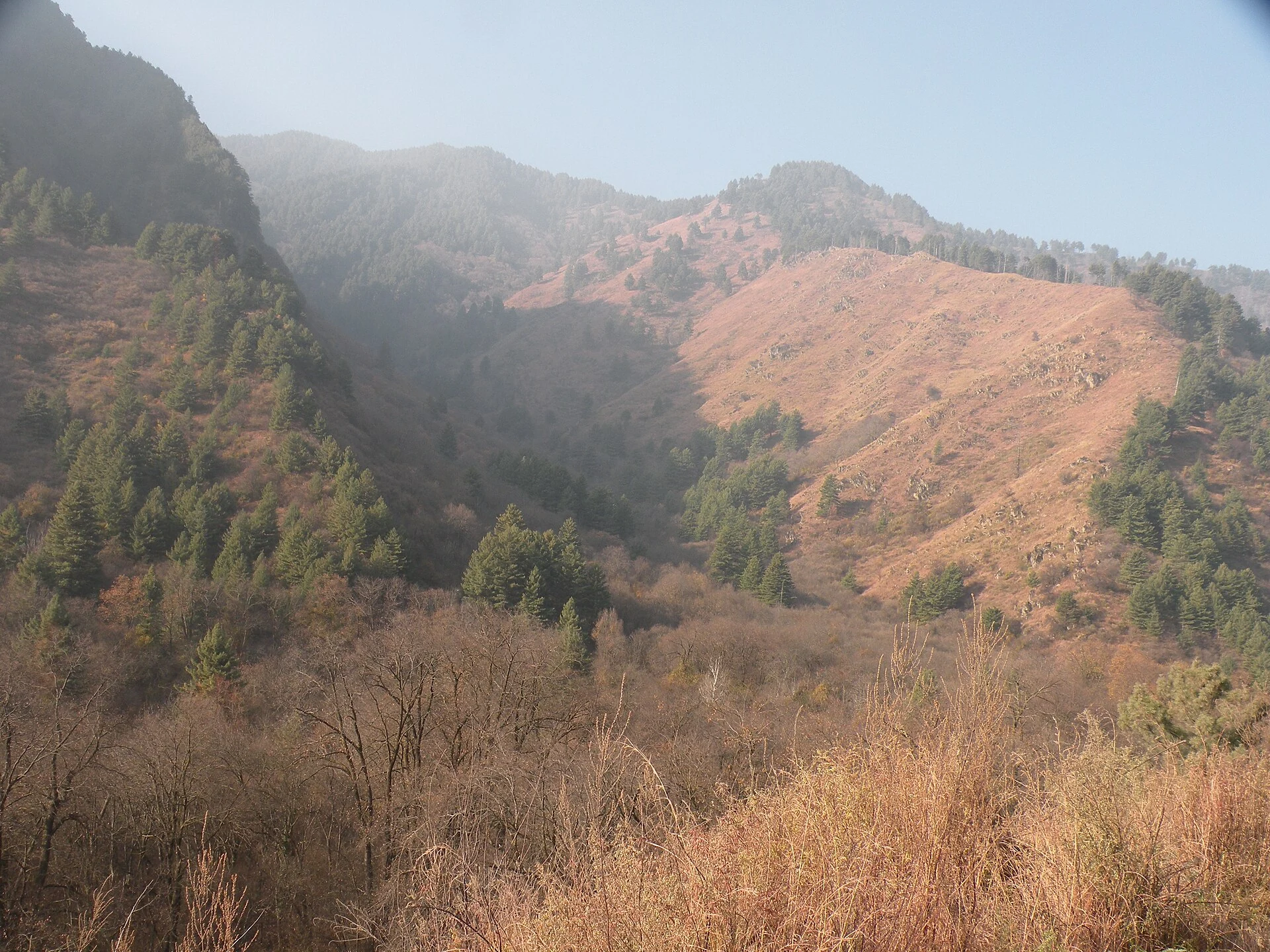
A protected landscape near Srinagar
Dachigam National Park is a protected area near Srinagar particularly associated with the hangul, or Kashmir stag. The district administration gives its area as approximately 141 square kilometres, records protection beginning in 1910 and identifies 1981 as the year of national-park designation. It also connects the earlier protection of the landscape with the supply of clean water to Srinagar. [1]
The name is commonly explained as “ten villages.” The district account presents that explanation in relation to villages relocated for the protected area. This origin story is distinct from the park’s modern purpose and does not mean that visitors should expect ten settlements inside an ordinary sightseeing circuit. [1]
Terrain and water
The referenced geographical overview describes a large difference in elevation between lower and upper parts of Dachigam. Sloping ground, rocky terrain and higher meadows create varied habitats rather than a single uniform forest. It also discusses the Dagwan watercourse and its relationship with the Sarband reservoir. These connections help explain why watershed functions and wildlife habitat belong in the same account of the park. [2]
Different elevations can have different seasonal conditions. A short walk in an accessible lower area should not be treated as a survey of the whole park. The location marker in this entry is a representative point taken from the geographical reference, not the entrance, the boundary or an approved trekking route. [2]
Hangul and other wildlife
The hangul is the species most closely associated with Dachigam in the district description. The Ministry of Tourism’s park account also discusses bears, leopards and birds, presenting the landscape as an important conservation setting. A species being recorded in a park is not a promise that an individual visitor will see it. [1][3]
Wildlife observation differs from watching captive animals. Quiet movement, distance and patience are more appropriate than attempting to approach, call or feed an animal. A good visit can involve recognising habitats and listening to birds even when a hoped-for mammal is not seen. Exact population figures require a dated survey and its method; this article does not treat a travel-page number as a current census.
Conservation and human–wildlife relationships
The Ministry’s account describes rescue and conflict-response work associated with wildlife in the Srinagar area. Such work reflects a relationship between protected habitat and surrounding human activity. Conservation is therefore not confined to the moment a tourist enters a gate; it includes monitoring, management and responses when animals and people come into contact. [3]
Visitors should follow the current park authority’s rules on entry, permitted areas and guides. Do not interpret an old booking link as proof that a service is still operated by the same organisation. Any commercial excursion should be checked separately from official permission to enter a protected area.
Reading the landscape photograph
The image included here is identified in its source as a view of Lower Dachigam and credited to wildlife scientist A. J. T. Johnsingh, with WWF-India and NCF named in the creator field. It shows wooded slopes and contrasting terrain rather than a staged wildlife encounter. The source’s date field is not reliable enough to assign a year, so the caption leaves the photograph undated. [4]
![[4]](https://commons.wikimedia.org/wiki/File:A_view_of_Lower_Dachigam_where_most_of_the_hangul_get_confined_in_winter,_AJT_Johnsingh.jpg)
The photograph illustrates one habitat view. It does not prove present vegetation condition throughout the park, establish a wildlife population or identify a route open to visitors. Retaining those limits makes it useful evidence without asking it to answer questions it cannot answer.
Planning and related places
Confirm entry procedures, operating conditions and any need for prior permission before travelling. Ask about the extent and terrain of a planned visit, not just its advertised duration. Keep waste out of the habitat and respect restrictions. For wider context, read Dal Lake, Nishat Bagh and the Srinagar district overview. The park should be approached as a conservation landscape with visitor access, rather than as another ornamental garden.
Photograph credit and map
Photograph: A. J. T. Johnsingh, WWF-India and NCF, via Wikimedia Commons, CC BY-SA 4.0. Resized and converted to WebP; no scene elements altered. Recorded date: Date not reliably established in source metadata..
Map marker: Representative park point from secondary reference; not an entrance, boundary or permitted route.
For regional airport, railway and bus connections, consult the district transport guide.
Research date: 13 October 2026. Confirm changing access arrangements before travelling.
Sources & references
[1] District Srinagar — Dachigam National Park
https://srinagar.nic.in/tourist-place/dachigam-national-park/ ↗
[2] Dachigam — secondary geographical reference
https://en.wikipedia.org/wiki/Dachigam_National_Park ↗
[3] Ministry of Tourism — Dachigam National Park
https://www.incredibleindia.gov.in/en/jammu-and-kashmir/srinagar/dachigam-national-park ↗
[4] Photograph source and licence
[5] District Srinagar — regional transport guide
Related reading
Chashma Shahi: The Royal Spring and Its Mughal Garden
The spring-centred design, Mughal commission, traditions and setting of Chashma Shahi.
Dal Lake: Waterways, Floating Gardens and Life on the Lake
An introduction to Dal Lake’s connected basins, working waterscape, floating gardens, boats and cultural setting.
Hazratbal Shrine: Devotion, History and Lakeside Architecture
Hazratbal’s devotional traditions, relic associations and the history of its lakeside architectural setting.