
Kokernag: Spring Channels, Garden and a Mountain-town Landscape
Kokernag is a town in Anantnag district's Breng Valley, known particularly for its freshwater springs and garden setting.
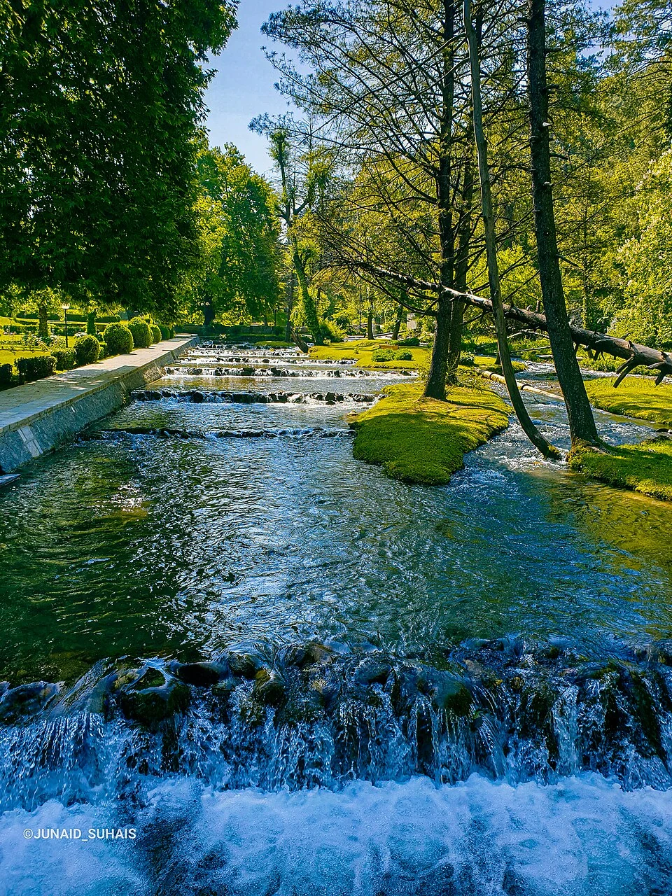
Kokernag is a town in Anantnag district's Breng Valley, known particularly for its freshwater springs and garden setting. The name can identify the settlement, a larger administrative area or the spring attraction. This article concentrates on the spring landscape while keeping those geographical meanings separate. A map marker for the garden does not represent the limits of the town or sub-district.[1]
Channels below a wooded hill
The district tourism account describes the spring as emerging at the base of a wooded slope and dividing into channels. Water and planting together create the landscape for which the place is known. Its explanation of the name connects the branching channels with the appearance of a hen's foot, a familiar local interpretation rather than conclusive historical proof of the word's origin.[2]
Kokernag is also associated with trout rearing. Published accounts identify a hatchery and managed pools linked with the wider fisheries sector. A fish-rearing facility is a working institution, distinct from a decorative garden pool or a natural stream. Its production methods and present visitor arrangements require their own records rather than being inferred from the spring's reputation.[1]
Water in a larger valley
The spring provides an entry point into the Breng landscape. Water channels, trees and nearby settlement connect natural features with human use. Looking at the source alone gives a narrower picture than considering how water moves through and beyond the landscaped area. Equally, an account of the surrounding town should not reduce every local livelihood to tourism.
Several explanations of Kokernag's name circulate in reference works. They are useful evidence of how people interpret the place, but presenting one as uncontested fact would conceal that variation. Historical claims about medicinal effects also need to be kept separate from contemporary evidence: this entry does not offer the spring water as a treatment or make a guarantee about drinking-water safety.
Read Kokernag with Achabal and Verinag to compare three distinct spring settings within Anantnag. Pahalgam provides a contrasting river-valley settlement. The official Kokernag page and district tourism table differ in road-distance figures, so this profile does not repeat a single distance as certain. Current routes and access can be checked independently of the historical and geographical account.
Photograph and map record
Photograph: Junaid Suhais via Wikimedia Commons. Licence: CC BY-SA 4.0. Recorded capture date: Taken on 28 May 2021, 09:07:13. Resized and converted to WebP; scene content unchanged. This is a dated view, not confirmation of the site’s present appearance.

Map marker: 33.584721, 75.308601. Representative location from the secondary geographical record, not a surveyed boundary or verified visitor entrance. View location on OpenStreetMap · View Google Maps · Google directions · OpenStreetMap directions.
Research checked: 14 October 2026. For a visit, confirm current access, transport and opening information with the relevant authorities. This encyclopedia profile provides geographical and historical context.
Sources & references
[1] Kokernag — secondary historical/geographical overview
https://en.wikipedia.org/wiki/Kokernag ↗
[2] Anantnag district: Kokernag spring and garden
https://anantnag.nic.in/tourist-place/kokernag/ ↗
Photograph and licence
Related reading
Achabal Garden: Spring-fed Terraces and Mughal Design
Achabal Garden is a Mughal garden in Anantnag district, arranged around a spring at the foot of a hill.
Kashmir Willow: Trees, Timber and Cricket-bat Making
Kashmir willow is associated with the production of cricket-bat timber and the work of bat makers in the Kashmir Valley.
Martand Sun Temple: Ruins, Royal Patronage and Kashmiri Architecture
The early medieval solar temple’s royal associations, central shrine, enclosure and surviving archaeological evidence.