
Markha Valley: Settlements and a Ladakh Walking Corridor
Markha Valley is an inhabited river valley and a well-known walking corridor in Ladakh. The Markha River is a tributary of the Zanskar, and settlement names along its valley include Skyu, Markha, Umlung and Hankar. A trekking description concerns journeys through this landscape, but the valley also contains places of everyday life rather than existing solely as a recreational route.
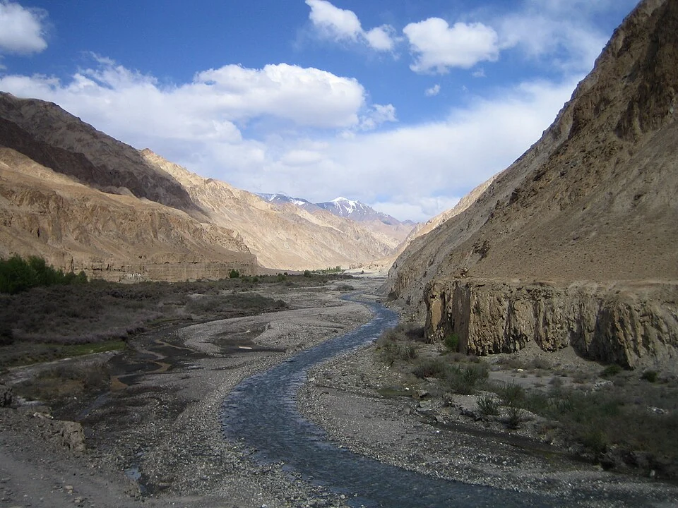
Markha Valley is an inhabited river valley and a well-known walking corridor in Ladakh. The Markha River is a tributary of the Zanskar, and settlement names along its valley include Skyu, Markha, Umlung and Hankar. A trekking description concerns journeys through this landscape, but the valley also contains places of everyday life rather than existing solely as a recreational route. [1]
River, villages and route choices
Accounts of the walking corridor describe approaches involving passes such as Ganda La and Gongmaru La. These are geographical connections rather than proof that every itinerary follows one fixed sequence. A route may use different roadheads or stages, so the itinerary’s named start and end should be checked separately from the general Markha Valley label. [1]
The Ladakh tourism portal identifies Markha among the region’s trekking experiences. A tourism listing establishes its place in the visitor landscape, while route conditions and access arrangements require more specific, current information. A general listing cannot certify a safe river crossing or an open pass. [2]
An inhabited mountain landscape
Village paths, fields and accommodation areas can overlap with walking routes. Their use by visitors does not remove the needs of residents or make every space a public campsite. Understanding the valley as inhabited geography provides a more complete account than describing it only through distance and dramatic scenery.
The valley’s relationship with the Hemis National Park landscape adds an ecological context. A park association should not be used to infer that every visible path has identical access rules. Protected-area boundaries, settlements and individual trails answer different geographical questions.
Orientation and evidence
The map marker represents a source-recorded valley reference rather than the entire route, a verified trailhead or a current crossing point. Read the Zanskar River and Hemis National Park entries to understand the wider drainage and protected landscape. The photograph records a particular view of Markha Valley with its date retained. Elevation changes, weather and route choice make a generic day count insufficient for planning; obtain current local guidance for an actual walk. This entry explains the corridor’s geographical relationships without presenting an unsurveyed itinerary as a guaranteed route.
Image and map record
Image: SlartibErtfass der bertige via Wikimedia Commons. Licence: CC BY-SA 3.0. Recorded capture date: 2006-06-04 11:13. Resized and converted to WebP; image content unchanged. This is a dated view, not confirmation of the site’s present appearance.
Map marker: 34.00305556, 77.21166667. Source-recorded orientation point, not a surveyed boundary, verified visitor entrance, campsite or present access guarantee. View location on OpenStreetMap · View Google Maps · Google directions · OpenStreetMap directions.
Research checked: 15 October 2026. For a visit, confirm current access, transport and opening information with the relevant authorities. This encyclopedia profile provides geographical and historical context.
Sources & references
[1] Wikipedia: Markha River (India) (secondary overview)
https://en.wikipedia.org/wiki/Markha_River_%28India%29 ↗
[2] Ladakh Tourism: Markha Valley trekking experience
https://tourism.ladakh.gov.in/ ↗
Image and licence
https://commons.wikimedia.org/wiki/File:Markha_Valley1.JPG ↗
Related reading
Barley in Ladakh: Cultivation and Regional Food Traditions
Barley is a cereal grass cultivated for its grain. In Ladakh it forms part of the relationship between farming, household food and a limited mountain
Chang La: A High Pass on the Route towards Pangong
Chang La is a high mountain pass in Ladakh on the road corridor towards Durbuk, Tangtse and Pangong. It connects the Leh-side approaches through Karu
Gurdwara Pathar Sahib: Sikh Tradition in the Indus Valley
Gurdwara Pathar Sahib is a Sikh place of worship in the Indus-valley corridor west of Leh.