
Chang La: A High Pass on the Route towards Pangong
Chang La is a high mountain pass in Ladakh on the road corridor towards Durbuk, Tangtse and Pangong. It connects the Leh-side approaches through Karu and Sakti with terrain farther east. The pass is one part of a multi-place journey rather than a synonym for Pangong Lake or its whole access route.
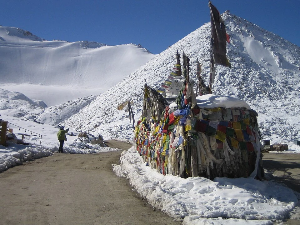
Chang La is a high mountain pass in Ladakh on the road corridor towards Durbuk, Tangtse and Pangong. It connects the Leh-side approaches through Karu and Sakti with terrain farther east. The pass is one part of a multi-place journey rather than a synonym for Pangong Lake or its whole access route.[1]
Pass and eastern corridor
Reference accounts place Chang La at roughly 5,360 metres and identify the road sequence through named settlements. These names help a reader understand the crossing's position. A route map is still needed to distinguish the summit from alternative roads and lower valley junctions.[1]
Leh's official adventure information refers to the Sakti area below Chang La within its regional landscape. Such an account places activities geographically without confirming that an operator, road or public facility is available on a particular day.[2]
Reading the landscape
The ascent, summit and descent expose different mountain views. Prayer flags or a roadside sign can help identify a photographed point, but neither describes the entire pass. A good caption keeps the source location and capture date separate from a general destination label.
Elevation values should also retain their precision. An approximate height is sufficient for understanding the crossing's high-altitude setting. Turning a rounded signboard figure into an exact decimal number would create a false impression of measurement.
Road condition, movement controls and the opening of alternative routes are time-sensitive matters. This entry does not reproduce an older construction announcement as proof of present access. General maps can show geography while leaving current travel arrangements unresolved.
Read Pangong Tso, Khardung La and Shey for different eastern, northern and Indus-valley subjects. Their links show how places connect without merging separate destinations. The pass marker is for orientation, not a verified parking space or a recommended medical stopping duration. Current travel information should identify the actual road and date.
Image and map record
Image: SlartibErtfass der bertige via Wikimedia Commons. Licence: CC BY-SA 3.0. Recorded capture date: 2008-10-02. Resized and converted to WebP; image content unchanged. This is a dated view, not confirmation of the site’s present appearance.

Map marker: 34.04704, 77.93054. Source-recorded location for orientation; not a surveyed boundary, verified public entrance, current access guarantee or authorised stopping point. View location on OpenStreetMap · View Google Maps · Google directions · OpenStreetMap directions.
Research checked: 14 October 2026. For a visit, confirm current access, transport and opening information with the relevant authorities. This encyclopedia profile provides geographical and historical context.
Sources & references
[1] Reference overview: Chang La
https://en.wikipedia.org/wiki/Chang_La ↗
[2] Leh administration: Sakti–Chang La landscape
https://leh.nic.in/tourism/adventures/ ↗
Image and licence
https://commons.wikimedia.org/wiki/File:Chang_La_prayer_flag.jpg ↗
Related reading
Barley in Ladakh: Cultivation and Regional Food Traditions
Barley is a cereal grass cultivated for its grain. In Ladakh it forms part of the relationship between farming, household food and a limited mountain
Fotu La: A High Pass on Ladakh’s Western Road Corridor
Fotu La, also written Fatu La, is a mountain pass on the Srinagar–Leh road corridor in western Ladakh. It lies near the approach to Lamayuru and forms
Gurdwara Pathar Sahib: Sikh Tradition in the Indus Valley
Gurdwara Pathar Sahib is a Sikh place of worship in the Indus-valley corridor west of Leh.