
Namika La: Pass and Mountain Road in Western Ladakh
Namika La is a mountain pass on the western Ladakh road corridor between Kargil and Leh. It is commonly translated as “Pillar of the Sky Pass.” Its significance lies in the road's passage between valley systems, rather than only in the name or a photograph of a summit sign.
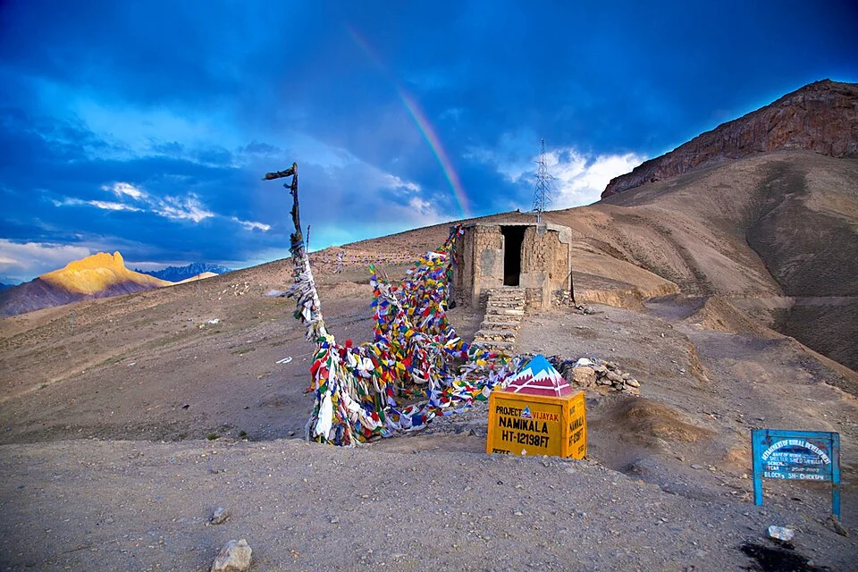
Namika La is a mountain pass on the western Ladakh road corridor between Kargil and Leh. It is commonly translated as “Pillar of the Sky Pass.” Its significance lies in the road's passage between valley systems, rather than only in the name or a photograph of a summit sign.[1]
A crossing between valleys
Reference descriptions place Namika La at roughly 3,700 metres and identify it with the Wakha and Bodh Karbu approaches. Fotu La is the other prominent high crossing in this part of the Srinagar–Leh journey. The two are separate passes, not alternative spellings for one location.[1]
The name and route association provide useful orientation, while the actual road geometry needs a map at a suitable scale. Mountain roads can follow branch valleys and bends rather than the shortest line between settlements. A pass marker cannot show that entire sequence.
Roadside records and mountain geography
A signboard photograph documents a labelled crossing at a particular time. The figure printed on it may use feet, metres or a rounded value. A reader should not manufacture extra precision by converting a rounded sign into a long decimal elevation.
Images also record a season and viewpoint. Clear skies or snow-free ground in one photograph do not establish the conditions during a later journey. A geographical entry can describe the route's role while current opening and stopping arrangements remain matters for dated transport information.
The pass is one element in a broader inhabited landscape. Villages, cultivated ground and roadside institutions occupy lower or adjoining terrain. Their histories are not explained simply by the altitude of the crossing, but links between entries help readers investigate the relationship.
Read Fotu La, Kargil District and Lamayuru Monastery for the western Ladakh corridor. Suru River supplies a separate valley subject. The marker identifies Namika La, not a campsite, surveyed parking area or guarantee of a currently open road. Practical directions require current local confirmation.
Image and map record
Image: Narender9 via Wikimedia Commons. Licence: CC BY-SA 4.0. Recorded capture date: 2016-06-11 18:50:19. Resized and converted to WebP; image content unchanged. This is a dated view, not confirmation of the site’s present appearance.

Map marker: 34.3832, 76.4603. Source-recorded location for orientation; not a surveyed boundary, verified public entrance, current access guarantee or authorised stopping point. View location on OpenStreetMap · View Google Maps · Google directions · OpenStreetMap directions.
Research checked: 14 October 2026. For a visit, confirm current access, transport and opening information with the relevant authorities. This encyclopedia profile provides geographical and historical context.
Sources & references
[1] Reference overview: Namika La
https://en.wikipedia.org/wiki/Namika_La ↗
Image and licence
https://commons.wikimedia.org/wiki/File:Namika_La_Pass.jpg ↗
Related reading
Chang La: A High Pass on the Route towards Pangong
Chang La is a high mountain pass in Ladakh on the road corridor towards Durbuk, Tangtse and Pangong. It connects the Leh-side approaches through Karu
Fotu La: A High Pass on Ladakh’s Western Road Corridor
Fotu La, also written Fatu La, is a mountain pass on the Srinagar–Leh road corridor in western Ladakh. It lies near the approach to Lamayuru and forms
Kargil District: Settlement, Trade and Administrative History
Kargil’s district history, mountain settlement, trade heritage and the distinction between older descriptions and the 2026 district changes.