
Shalimar Bagh: Mughal Patronage, Water and Garden Architecture
Shalimar’s imperial patronage, central water axis, successive historical phases and heritage context.
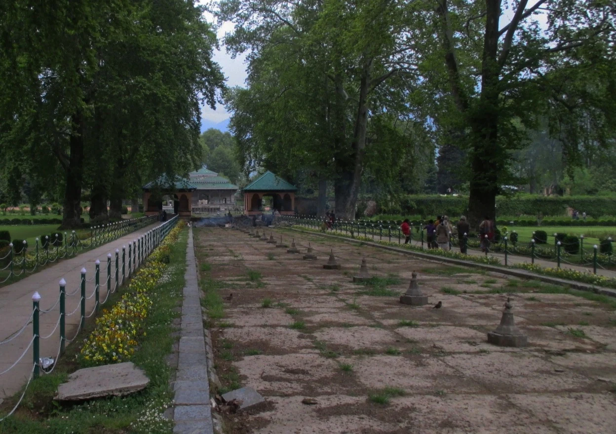
An imperial garden beside Dal
Shalimar Bagh is a Mughal garden in Srinagar, associated with Emperor Jahangir, Nur Jahan and later additions under Shah Jahan. Its significance lies in the relationship between planting, water, pavilions and the surrounding landscape. It is a designed garden rather than simply a lawn beside Dal Lake. The district administration records a channel connecting the garden with the lake and identifies Shalimar as a public park. [1]
Patronage and successive phases
The district and Ministry of Tourism accounts date Jahangir’s garden to 1619 and associate its creation with Nur Jahan. Farah Baksh appears as an earlier name in these descriptions. Later work under Shah Jahan added to the garden, meaning that the present landscape cannot be explained as a single construction event. Changes in patronage, use and maintenance form part of its history. [1][2]
UNESCO’s submission dates the early phase to around 1620, rather than 1619. [3]
Water as the organising line
The district account describes Shah Nahar, the central channel, as the garden’s principal axis. Water descends between levels, with pools, fountains and pavilions arranged in relation to it. Chinar trees frame views along the garden. These features allow a visitor to follow a planned sequence rather than encounter unrelated flowerbeds. The route of water also makes the garden’s sloping setting part of its design. [1]
It is useful to observe the landscape from different positions: along the channel, from a side path and near a pavilion. Each position gives a different relationship between the built structure, planted space and distant setting. That observation does not require assuming that today’s planting exactly reproduces a seventeenth-century scheme.
Pavilions and courtly space
The Ministry of Tourism describes Shalimar through its symmetry, water features and pavilions, connecting it with Mughal courtly life. The historic distinction between public and more private spaces gives the garden a social dimension as well as an aesthetic one. A pavilion is consequently more than a convenient background for a photograph: its place in the garden’s arrangement helps explain how the landscape was used. [2]
Published descriptions do not all count Shalimar’s terraces in the same way. This entry therefore avoids a single definitive number. The important, consistently documented relationship is between successive levels and the central water axis. A detailed architectural survey should explain what it counts before comparing terrace totals.
Heritage recognition
Shalimar appears in India’s UNESCO Tentative List submission for Kashmir’s Mughal gardens; this is not World Heritage inscription. [3]
Understanding that distinction is important when reading travel advertisements. Heritage significance does not depend on exaggerating a designation. The garden can be valued for its historical fabric and landscape relationships while its formal international status is described accurately.
Reading the photograph
The image supplied with this article records Shalimar in April 2013. Its view along a water feature shows how a linear element directs attention into the garden. The photograph also reminds readers that channels can look different depending on maintenance and season. It should not be used to promise active fountains, a particular planting display or identical conditions on a future visit. [4]
![[4]](https://commons.wikimedia.org/wiki/File:A_view_of_Shalimar_Bagh,_Srinagar,_in_2013.jpg)
Access and related gardens
Confirm opening arrangements and access with the current operator. For visitors with limited mobility, ask specifically about steps and the route between levels. Follow paths and protect trees and stonework. Compare Shalimar with Nishat Bagh and the spring-centred Chashma Shahi; these are connected subjects with distinctive layouts, not interchangeable versions of the same garden.
Photograph credit and map
Photograph: Billjones94, via Wikimedia Commons, CC BY-SA 4.0. Resized and converted to WebP; no scene elements altered. Recorded date: 2013-04-27 05:42:17.
Map marker: UNESCO Tentative List coordinates, converted from DMS; representative garden location.
For regional airport, railway and bus connections, consult the district transport guide.
Research date: 13 October 2026. Confirm changing access arrangements before travelling.
Sources & references
[1] District Srinagar — Shalimar Garden
https://srinagar.nic.in/tourist-place/shalimar-garden/ ↗
[2] Ministry of Tourism — Shalimar Bagh
https://www.incredibleindia.gov.in/en/jammu-and-kashmir/srinagar/shalimar-bagh ↗
[3] UNESCO — Mughal Gardens in Kashmir, Tentative List
https://whc.unesco.org/en/tentativelists/5580/ ↗
[4] Photograph source and licence
https://commons.wikimedia.org/wiki/File:A_view_of_Shalimar_Bagh,_Srinagar,_in_2013.jpg ↗
[5] District Srinagar — regional transport guide
Related reading
Chashma Shahi: The Royal Spring and Its Mughal Garden
The spring-centred design, Mughal commission, traditions and setting of Chashma Shahi.
Dachigam National Park: Landscape, Hangul and Conservation
Dachigam’s protection history, varied terrain, water connections and wildlife-conservation context.
Dal Lake: Waterways, Floating Gardens and Life on the Lake
An introduction to Dal Lake’s connected basins, working waterscape, floating gardens, boats and cultural setting.