
Shyok River: Valley, Tributaries and Northern Ladakh
The Shyok is a major tributary of the Indus whose course passes through northern Ladakh and continues into Baltistan. Within Ladakh, its valley is closely connected with Nubra settlements and mountain-road geography. This article focuses on that regional course while acknowledging that the whole river extends beyond one administrative area.
The Shyok is a major tributary of the Indus whose course passes through northern Ladakh and continues into Baltistan. Within Ladakh, its valley is closely connected with Nubra settlements and mountain-road geography. This article focuses on that regional course while acknowledging that the whole river extends beyond one administrative area.[1]
Shyok and Nubra
Reference accounts connect the upper river with the Rimo glacier system and identify the Nubra among its tributaries. The two rivers meet in the Nubra landscape. A valley commonly called Nubra therefore includes ground influenced by more than one named watercourse.[1]
The official Ladakh Nubra account emphasises the combined valley setting of the Shyok and the river also called Siachan. That context helps explain why a river profile should identify its exact channel rather than treat every image labelled “Nubra Valley” as a photograph of the Nubra River.[2]
Water and settlement patterns
Mountain slopes, broad valley ground and cultivated patches occupy different parts of this landscape. Water is central to understanding their relationship, but a green field or a sand dune alone does not reveal the whole irrigation or sediment history of a settlement.
Roads may follow a river corridor while crossing tributaries and changing sides. The presence of a road in a map is not proof that a particular riverbank is a public stopping place. A route description needs current information about the actual road, not only the river's geographical name.
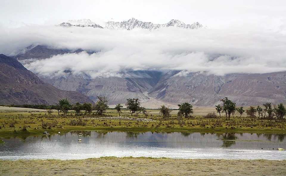
The accompanying photograph is source-identified at Hunder. It documents a Ladakh reach rather than using an image from the river farther downstream. That distinction keeps the illustration within the article's regional focus without pretending that the river stops at a political boundary.
Read Turtuk, Hunder and Nubra River for related settlement and tributary entries. The marker identifies a representative river-view setting at Hunder, not the Shyok's source, mouth or complete course. Its assignment to Nubra follows the encyclopedia's current district framework; older sources may use Leh district for the same location.
Image and map record
Image: Rupak Sarkar via Wikimedia Commons. Licence: CC BY-SA 4.0. Recorded capture date: 2014-09-06 17:43:02. Resized and converted to WebP; image content unchanged. This is a dated view, not confirmation of the site’s present appearance.

Map marker: 34.575836, 77.494823. Representative Hunder village context marker for the Shyok corridor, not a verified riverbank entrance or full river course. View location on OpenStreetMap · View Google Maps · Google directions · OpenStreetMap directions.
Research checked: 14 October 2026. For a visit, confirm current access, transport and opening information with the relevant authorities. This encyclopedia profile provides geographical and historical context.
Sources & references
[1] Reference overview: Shyok River
https://en.wikipedia.org/wiki/Shyok_River ↗
[2] Ladakh administration: Nubra valley and rivers
https://ladakh.gov.in/places-centres/nubra/ ↗
Image and licence
https://commons.wikimedia.org/wiki/File:Shyok_river_at_Hunder,_Nubra_valley.jpg ↗
Related reading
Buckwheat in Ladakh: Crop, Food and Mountain Fields
Buckwheat is a seed crop used like a cereal even though it is not a grass and is not closely related to wheat. Common buckwheat belongs to the knotwee
Chenab River: A Mountain River across the Jammu Region
The Chenab is a major Himalayan river flowing through the Jammu region. Its mountain valleys connect settlements, bridges and hydroelectric projects,
Diskit Monastery: Gelug Heritage and the Nubra Valley
Nubra’s Gelug monastery, hillside architecture, community life and the newer district classification.