
Turtuk: Village, Orchards and Balti Heritage in Nubra
Turtuk is a village in the Shyok-valley corridor of Nubra, associated with Balti language and cultural traditions.
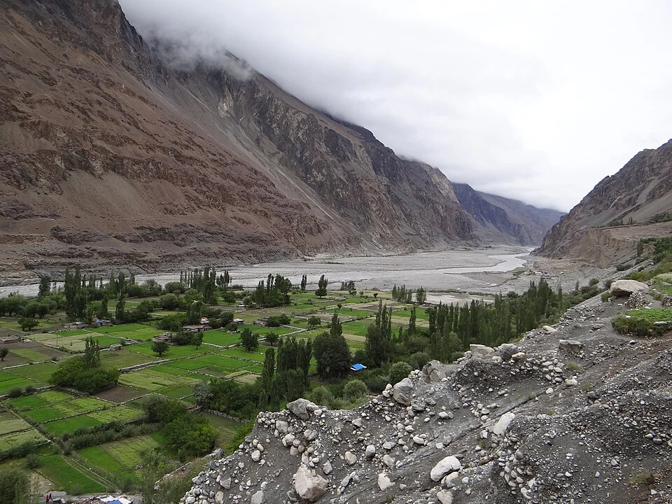
Turtuk is a village in the Shyok-valley corridor of Nubra, associated with Balti language and cultural traditions. Its houses, cultivated ground and orchards occupy a mountain setting that differs from an image of Ladakh composed only of monasteries and bare slopes. A village account should keep its residents and working landscape visible.[1]
Village and regional history
Turtuk's modern administrative history is connected with the 1971 India–Pakistan conflict and subsequent Indian administration of the area. That historical change should be distinguished from the longer cultural relationships of the village. A political boundary event does not define the entire origin of a language, household or farming tradition.[1]
The official Leh tourism account identifies Turtuk as a Balti village and records its particular religious and language setting. This is a useful counterpoint to a uniform account of Ladakh: neighbouring valleys and settlements can have different histories and practices.[2]
Orchards and built landscape
Orchards and cultivated patches make the relationship between water, settlement and land especially apparent. A panoramic photograph can show their arrangement while leaving the work of irrigation, maintenance and harvest unseen. The built village and its surrounding ground should therefore be considered together.
Cultural descriptions also benefit from identifying their source and scale. A guide's account, household recollection and official village record provide different evidence. None should be used to claim that every resident practises an identical custom. Respectful interpretation leaves room for variation and change within a community.
This entry uses Nubra under Ladakh's 2026 district framework, while older records often place Turtuk in Leh district. Compare Hunder and Diskit as separate Nubra subjects. Ladakhi Language explains why written and spoken regional categories need care; Turtuk's Balti identity should not simply be relabelled as the same speech as central Leh. The marker is a settlement point, not a map of the entire cultural region.
Photograph and map record
Photograph: Rajnish71 via Wikimedia Commons. Licence: CC BY-SA 4.0. Recorded capture date: 2014-09-05 12:16:49. Resized and converted to WebP; scene content unchanged. This is a dated view, not confirmation of the site’s present appearance.

Map marker: 34.847, 76.827. Representative source-record location, not a surveyed boundary or verified visitor entrance. Confirm actual access and accessibility locally. View location on OpenStreetMap · View Google Maps · Google directions · OpenStreetMap directions.
Research checked: 14 October 2026. For a visit, confirm current access, transport and opening information with the relevant authorities. This encyclopedia profile provides geographical and historical context.
Sources & references
[1] Turtuk — secondary historical/geographical overview
https://en.wikipedia.org/wiki/Turtuk ↗
[2] Leh district tourism account: Turtuk Balti context
https://leh.nic.in/swadesh-darshan-leh/ ↗
Photograph and licence
https://commons.wikimedia.org/wiki/File:River_Shyok,_Turtuk_Village,_Ladakh.JPG ↗
Related reading
Basohli: Ravi-side Town and a Centre of Pahari Painting
Basohli is a town in Kathua district, in the Jammu region, overlooking the Ravi river landscape.
Bhaderwah: Town, Valley and the Bhadarwahi Cultural Landscape
The mountain town and valley, local language identity and relationship with surrounding destinations.
Diskit Monastery: Gelug Heritage and the Nubra Valley
Nubra’s Gelug monastery, hillside architecture, community life and the newer district classification.