
Vishansar Lake: Mountain Water in the Ganderbal Landscape
Vishansar Lake is a high-mountain lake in the Ganderbal landscape near the Sonamarg-side ranges. It is often encountered in accounts of the Kashmir Great Lakes walking circuit. The lake is an individual waterbody with its own basin, rather than another name for the complete trek or for all lakes reached from Sonamarg.
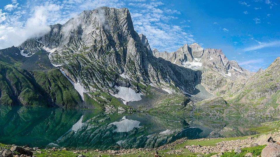
Vishansar Lake is a high-mountain lake in the Ganderbal landscape near the Sonamarg-side ranges. It is often encountered in accounts of the Kashmir Great Lakes walking circuit. The lake is an individual waterbody with its own basin, rather than another name for the complete trek or for all lakes reached from Sonamarg. [1]
A basin in a mountain landscape
Published descriptions place Vishansar at roughly 3,710 metres above sea level. Such a height provides geographical context; it should not be confused with the elevation of a roadhead or every point along an approach. A lake surface, surrounding slope and pass above the basin occupy different levels of terrain. [1]
Krishansar lies nearby and has its own entry. The close relationship between the two makes comparison useful, but their names and coordinates should remain distinct. A viewpoint can contain both basins while the caption or map must still identify which lake is the main subject.
Water and visual interpretation
A lake photograph reflects weather, season, light and the position of the camera. Deep blue water in one image does not establish the same appearance throughout the year. Nor can colour alone measure water chemistry, depth or suitability for drinking.
Mountain lakes connect with their catchments through snow, rainfall and the slopes that drain towards them. Understanding the catchment gives a fuller explanation than describing the shoreline in isolation. Any precise account of drainage requires an appropriate geographical source rather than an inference from the visible shape of a photograph.
A place within a route
Read Vishansar with Krishansar, Sonamarg and the Kashmir Great Lakes entry to separate the lake’s identity from the itinerary that links it with other places. The coordinates provide basin orientation, not a verified campsite or an authorized route across a pass. A lake reached on foot should not be presented as a roadside destination merely because a map application offers directions towards its coordinates. Current access and route conditions require local confirmation. The photograph is retained as a dated landscape record, allowing readers to appreciate the lake while keeping practical route planning separate from its encyclopedia description.
Image and map record
Image: Rohit Sharma via Wikimedia Commons. Licence: CC BY-SA 4.0. Recorded capture date: 2023-08-15 08:06:47. Resized and converted to WebP; image content unchanged. This is a dated view, not confirmation of the site’s present appearance.
Map marker: 34.388119, 75.11875. Source-recorded orientation point, not a surveyed boundary, verified visitor entrance, campsite or present access guarantee. View location on OpenStreetMap · View Google Maps · Google directions · OpenStreetMap directions.
Research checked: 15 October 2026. For a visit, confirm current access, transport and opening information with the relevant authorities. This encyclopedia profile provides geographical and historical context.
Sources & references
[1] Wikipedia: Vishansar Lake (secondary overview)
https://en.wikipedia.org/wiki/Vishansar_Lake ↗
Image and licence
https://commons.wikimedia.org/wiki/File:Vishansar_Lake,_Sonmarg,_Kashmir.jpg ↗
Related reading
Baltal: A Valley Camp and Pilgrimage Approach near Sonamarg
Baltal is a valley camp area near Sonamarg in Ganderbal district, widely associated with an approach to the Amarnath pilgrimage. The place and the sea
Dal Lake: Waterways, Floating Gardens and Life on the Lake
An introduction to Dal Lake’s connected basins, working waterscape, floating gardens, boats and cultural setting.
Ganderbal: Town and the Sind Valley Corridor
Ganderbal is a town and district headquarters in Kashmir's Sind valley corridor. The river and roads connect it with settlements and mountain approach