
Baltal: A Valley Camp and Pilgrimage Approach near Sonamarg
Baltal is a valley camp area near Sonamarg in Ganderbal district, widely associated with an approach to the Amarnath pilgrimage. The place and the seasonal pilgrimage arrangements are related but distinct. Baltal exists as a geographical setting even when temporary camp activity is absent.
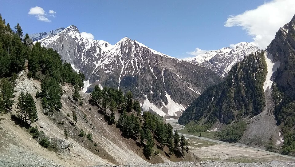
Baltal is a valley camp area near Sonamarg in Ganderbal district, widely associated with an approach to the Amarnath pilgrimage. The place and the seasonal pilgrimage arrangements are related but distinct. Baltal exists as a geographical setting even when temporary camp activity is absent.[1]
Camp and mountain corridor
The Ganderbal district's official material identifies the Baltal approach in its pilgrimage administration. A seasonal programme involves registration, route management and facilities that may change from year to year. A historical photograph of tents cannot establish the arrangements for a current pilgrimage.[2]
Reference descriptions place Baltal close to the Sonamarg and Zoji La corridor. Its proximity to those landmarks is useful orientation, but distances between named places should not be turned into an assumed walking time or an unverified transport timetable.[1]
Permanent landscape, seasonal use
A camp changes the appearance and use of a valley floor. Temporary structures, gathering areas and paths can be visible during an event and absent at another time. The source image here identifies an empty camping ground within the surrounding mountain landscape, rather than a live operational camp.
The pilgrimage route needs its own current assessment. Terrain, authorised movement and available facilities cannot be inferred from a straight line on a map. An encyclopedia entry can explain the place's role while directing practical planning towards dated official information.
The distinction between a camp area and a town is useful for nearby-place search. A general map result might show services in Sonamarg without establishing that the same services operate at Baltal. Every facility needs a named location and a current source.
Read Sonamarg, Zoji La and Sind River for the surrounding corridor. Pahalgam supplies a separate pilgrimage-region comparison, not an interchangeable starting point. The map locates the Baltal area; it does not confirm an open camp, current registration eligibility or permission to follow a pilgrimage trail.
Image and map record
Image: Nckumbhkar via Wikimedia Commons. Licence: CC BY-SA 4.0. Recorded capture date: Taken on 27 May 2017, 14:03:40. Resized and converted to WebP; image content unchanged. This is a dated view, not confirmation of the site’s present appearance.

Map marker: 34.257, 75.416. Source-recorded location for orientation; not a surveyed boundary, verified public entrance, current access guarantee or authorised stopping point. View location on OpenStreetMap · View Google Maps · Google directions · OpenStreetMap directions.
Research checked: 14 October 2026. For a visit, confirm current access, transport and opening information with the relevant authorities. This encyclopedia profile provides geographical and historical context.
Sources & references
[1] Reference overview: Baltal, Jammu and Kashmir
https://en.wikipedia.org/wiki/Baltal%2C_Jammu_and_Kashmir ↗
[2] Ganderbal administration: pilgrimage and Baltal programme records
Image and licence
https://commons.wikimedia.org/wiki/File:BaltalAmarnath.jpg ↗
Related reading
Chandanwari: A Mountain Approach above Pahalgam
Chandanwari, also written Chandanwadi, is a mountain approach above Pahalgam in Anantnag district. It appears in accounts of the Pahalgam-side Amarnat
Ganderbal: Town and the Sind Valley Corridor
Ganderbal is a town and district headquarters in Kashmir's Sind valley corridor. The river and roads connect it with settlements and mountain approach
Gangabal Lake: Mountain Water and the Haramukh Landscape
Gangabal, also written Gangbal and associated with the name Haramukh Ganga, is a mountain lake below Haramukh in Ganderbal district. Its water, surrou