
Ganderbal: Town and the Sind Valley Corridor
Ganderbal is a town and district headquarters in Kashmir's Sind valley corridor. The river and roads connect it with settlements and mountain approaches farther northeast. The town and the district share a name, but the district's lakes and tourist destinations should not all be described as if they lie inside the urban centre.
Ganderbal is a town and district headquarters in Kashmir's Sind valley corridor. The river and roads connect it with settlements and mountain approaches farther northeast. The town and the district share a name, but the district's lakes and tourist destinations should not all be described as if they lie inside the urban centre.[1]
Town, name and river
The district administration identifies Ganderbal town as the headquarters and associates its name with the spring Ganderbhavan. That place-name account supplies historical context while remaining distinct from a complete, independently dated founding history.[2]
The official district overview places Ganderbal at approximately 34.23° north and 74.78° east and identifies Nallah Sindh as a major Jhelum tributary. Its discussion of irrigation and electricity explains the river's regional importance without locating every facility at the town-centre point.[3]
Regional connections
Roads through the district lead towards Kangan and Sonamarg, while other routes connect with the Srinagar-side valley. Those connections help explain the headquarters' position. A road corridor is not a single neighbourhood, and a district destination list is not a walking-distance itinerary.
The Census of India's Ganderbal handbook provides town and village data for the 2011 reference period. Population and settlement statistics should retain their year and unit. The total for the whole district must not be presented as the population of Ganderbal town.[4]
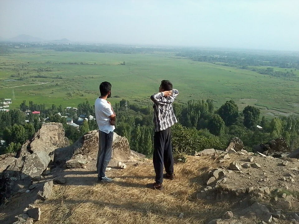
A photograph of the area can reveal built ground, vegetation and hills. It cannot independently identify the boundaries of a municipal unit or the purpose of every building. The image caption therefore preserves its source's description rather than claiming a complete institutional survey.
Read Sind River, Manasbal Lake and Sonamarg for connected but separate geographical subjects. Gangabal Lake is a mountain destination within the wider district, not a central-town waterbody. The marker supplies town orientation rather than an urban boundary, verified office entrance or suitable starting point for a mountain trek. Precise directions require the actual destination's location.
Image and map record
Image: Owais khursheed via Wikimedia Commons. Licence: CC BY-SA 4.0. Recorded capture date: 2014-06-29 17:16:41. Resized and converted to WebP; image content unchanged. This is a dated view, not confirmation of the site’s present appearance.

Map marker: 34.23, 74.78. Source-recorded location for orientation; not a surveyed boundary, verified public entrance, current access guarantee or authorised stopping point. View location on OpenStreetMap · View Google Maps · Google directions · OpenStreetMap directions.
Research checked: 14 October 2026. For a visit, confirm current access, transport and opening information with the relevant authorities. This encyclopedia profile provides geographical and historical context.
Sources & references
[1] Reference overview: Ganderbal
https://en.wikipedia.org/wiki/Ganderbal ↗
[2] Ganderbal administration: history
https://ganderbal.nic.in/history/ ↗
[3] Ganderbal administration: district geography
https://ganderbal.nic.in/about-district/ ↗
[4] Census of India: Ganderbal handbook, 2011
Image and licence
https://commons.wikimedia.org/wiki/File:Ganderbal_from_rangil_mountain.jpg ↗
Related reading
Anantnag: Town, Springs and Southern Kashmir
Anantnag is a major town and district headquarters in southern Kashmir. The name also refers to the surrounding district, so town history and district
Aru: Village and Mountain Landscape above Pahalgam
Aru is a village and mountain visitor destination in Anantnag district, above the Pahalgam area. It is also known as Adav in Kashmiri. Meadows, settle
Baltal: A Valley Camp and Pilgrimage Approach near Sonamarg
Baltal is a valley camp area near Sonamarg in Ganderbal district, widely associated with an approach to the Amarnath pilgrimage. The place and the sea