
Hemis Festival: Masked Performance and Monastic Celebration
The Hemis Festival is a religious celebration held at Hemis Monastery in Ladakh. It honours Padmasambhava, a major figure in Tibetan Buddhist tradition, and is especially recognised for masked cham performances in the monastery courtyard. The festival and the monastery are connected subjects, but one describes an occasion and the other an enduring institution.
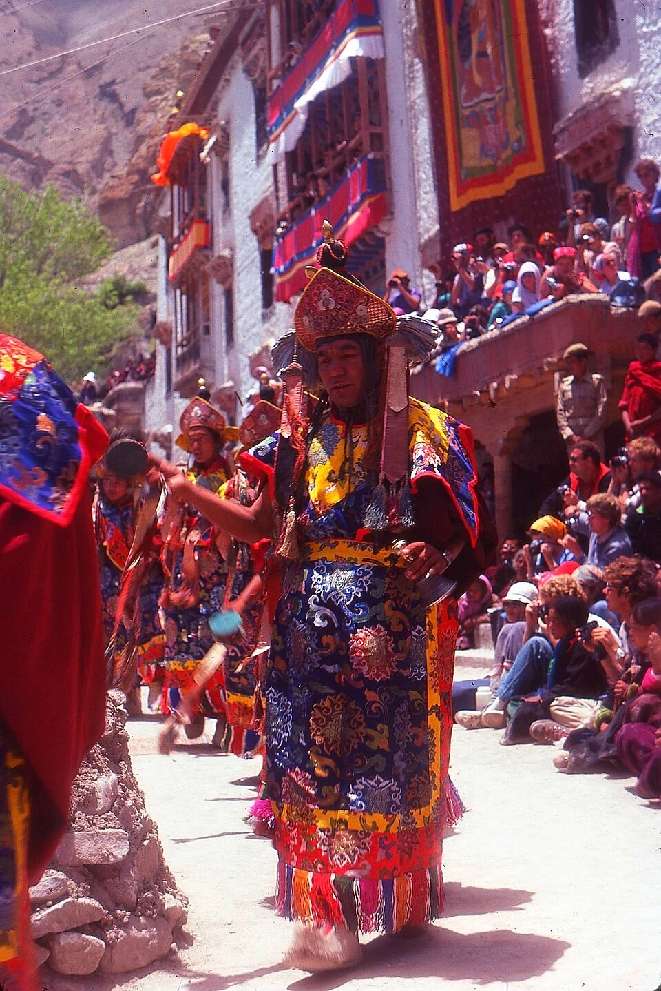
The Hemis Festival is a religious celebration held at Hemis Monastery in Ladakh. It honours Padmasambhava, a major figure in Tibetan Buddhist tradition, and is especially recognised for masked cham performances in the monastery courtyard. The festival and the monastery are connected subjects, but one describes an occasion and the other an enduring institution.[1]
Performance in a monastic setting
The Ministry of Tourism identifies masked ritual performance as a central feature of the Hemis celebration. Masks, robes and musical accompaniment belong to a religious setting rather than an ordinary theatrical costume display. A visitor's photograph captures an outward appearance; the performers' tradition supplies the interpretation of its figures and sequence.[2]
Hemis belongs to the Drukpa lineage. Its courtyard provides a shared setting where performers and spectators occupy different positions. The scale of the crowd and the visibility of a particular dance can vary, so an image from one year should retain its date rather than be presented as a live view.[1]
Festival date and interpretation
The celebration follows a lunar religious calendar. Its Gregorian date needs to be checked for the named year, particularly when planning transport or accommodation. General descriptions of an annual festival should not become an undated booking promise.
Watching the full sequence is different from viewing a single mask. The relation between movement, music and ceremonial order helps make a performance intelligible. Short captions can identify the event while leaving room for a more detailed explanation from the monastery or knowledgeable local interpreters.
Read Hemis Monastery for the site and Losar for a separate New Year celebration. Thiksey Monastery offers another institutional setting, without implying that its observances are the same. The map points to Hemis for orientation; it does not show a festival ticket office or confirm that courtyard access will be unrestricted. Current arrangements belong to a dated monastery or organiser notice.
Image and map record
Image: Avalonmick via Wikimedia Commons. Licence: CC BY-SA 4.0. Recorded capture date: 1982-06-08. Resized and converted to WebP; image content unchanged. This is a dated view, not confirmation of the site’s present appearance.

Map marker: 33.912475, 77.70283333. Source-recorded location for orientation; not a surveyed boundary, verified public entrance, current access guarantee or authorised stopping point. View location on OpenStreetMap · View Google Maps · Google directions · OpenStreetMap directions.
Research checked: 14 October 2026. For a visit, confirm current access, transport and opening information with the relevant authorities. This encyclopedia profile provides geographical and historical context.
Sources & references
[1] Reference overview: Hemis Festival
https://en.wikipedia.org/wiki/Hemis_Festival ↗
[2] Ministry of Tourism: Ladakh festivals
https://www.incredibleindia.gov.in/en/ladakh ↗
Image and licence
https://commons.wikimedia.org/wiki/File:12_Hemis_Mela_071982.jpg ↗
Related reading
Barley in Ladakh: Cultivation and Regional Food Traditions
Barley is a cereal grass cultivated for its grain. In Ladakh it forms part of the relationship between farming, household food and a limited mountain
Chang La: A High Pass on the Route towards Pangong
Chang La is a high mountain pass in Ladakh on the road corridor towards Durbuk, Tangtse and Pangong. It connects the Leh-side approaches through Karu
Gurdwara Pathar Sahib: Sikh Tradition in the Indus Valley
Gurdwara Pathar Sahib is a Sikh place of worship in the Indus-valley corridor west of Leh.