
Sopore: Town, Jhelum and the Orchard Economy
Sopore is a town in Baramulla district in northern Kashmir, associated with the Jhelum and the region's fruit economy. Its market role connects orchard production with trading and transport, while the town also contains neighbourhoods and institutions that cannot be reduced to a single wholesale market.
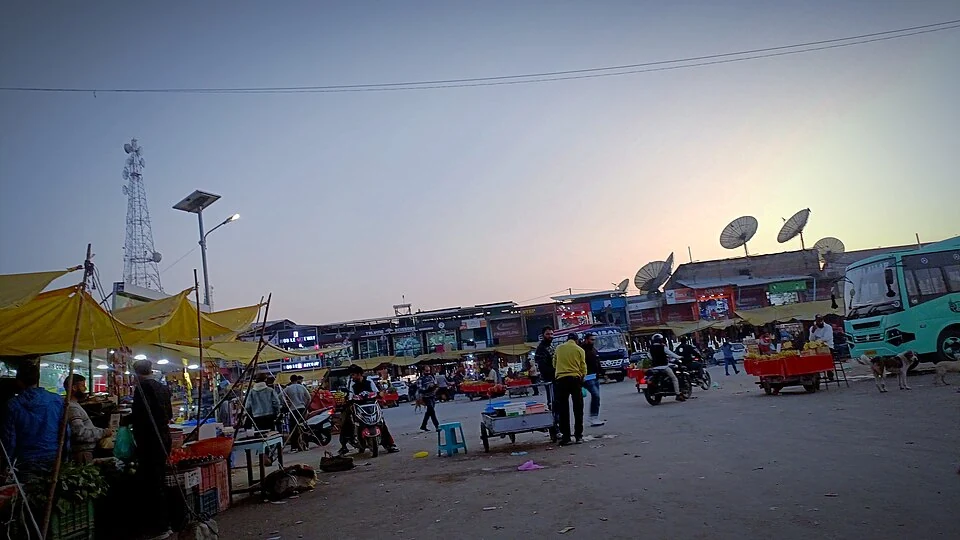
Sopore is a town in Baramulla district in northern Kashmir, associated with the Jhelum and the region's fruit economy. Its market role connects orchard production with trading and transport, while the town also contains neighbourhoods and institutions that cannot be reduced to a single wholesale market.[1]
Fruit trade and urban life
The Jammu and Kashmir Trade Promotion Organisation's Baramulla profile identifies Sopore's fruit mandi and its connection with apple production. The commercial association explains the familiar “Apple Town” description. It is more useful to describe the market's role than to repeat an undated ranking of its size across Asia.[2]
The Horticulture Planning and Marketing Department's citizen charter lists the Sopore fruit and vegetable market within its service network. A named market record is evidence of an institution; current fees, trading arrangements and opening schedules need their own dated information.[3]
Town and surrounding landscape
Orchards supplying a market need not lie inside the town's municipal boundary. The trading network can draw produce from a broader area. A town profile and an agricultural-production account should therefore use different geographical scales.
The Jhelum and the nearby Wular landscape add a second way to understand Sopore's location. Watercourses, roads and built neighbourhoods create different connections. A river-side photograph and a market photograph show complementary views rather than competing definitions of the whole town.
The supplied image records the main bus-stand setting identified by its source. It documents one urban place at one time, not the current timetable or the location of every transport operator. Public-life images become more informative when their specific subject remains visible in the caption.
Read Kashmir Apples, Wular Lake and Jhelum River for production and geographical context. The town marker is a representative point, not the fruit-market gate, bus-stand entrance or legal urban boundary. A nearby-service search should locate the actual facility rather than assume that the town-centre marker identifies it.
Image and map record
Image: PoshFulay via Wikimedia Commons. Licence: CC BY 4.0. Recorded capture date: 2024-10-31. Resized and converted to WebP; image content unchanged. This is a dated view, not confirmation of the site’s present appearance.

Map marker: 34.3, 74.47. Source-recorded location for orientation; not a surveyed boundary, verified public entrance, current access guarantee or authorised stopping point. View location on OpenStreetMap · View Google Maps · Google directions · OpenStreetMap directions.
Research checked: 14 October 2026. For a visit, confirm current access, transport and opening information with the relevant authorities. This encyclopedia profile provides geographical and historical context.
Sources & references
[1] Reference overview: Sopore
https://en.wikipedia.org/wiki/Sopore ↗
[2] JKTPO: Baramulla profile and Sopore fruit market
https://jktpo.jk.gov.in/files/Baramulla_Export_Action_plans.pdf ↗
[3] Horticulture Planning and Marketing: citizen charter and market network
https://jkdhpm.in/pdf/CitizensCharter.pdf ↗
Image and licence
https://commons.wikimedia.org/wiki/File:Sopore_main_bus_stand.jpg ↗
Related reading
Anantnag: Town, Springs and Southern Kashmir
Anantnag is a major town and district headquarters in southern Kashmir. The name also refers to the surrounding district, so town history and district
Aru: Village and Mountain Landscape above Pahalgam
Aru is a village and mountain visitor destination in Anantnag district, above the Pahalgam area. It is also known as Adav in Kashmiri. Meadows, settle
Baramulla Railway Station: Rail and Northern Kashmir
Baramulla railway station serves the northern Kashmir town and its surroundings. The district administration describes the railway connection as part