
Gangabal Lake: Mountain Water and the Haramukh Landscape
Gangabal, also written Gangbal and associated with the name Haramukh Ganga, is a mountain lake below Haramukh in Ganderbal district. Its water, surrounding slopes and proximity to Nundkol give it a distinctive high-mountain setting. The lake is a geographical feature and a place of cultural significance, rather than merely a named stop on a packaged trek.
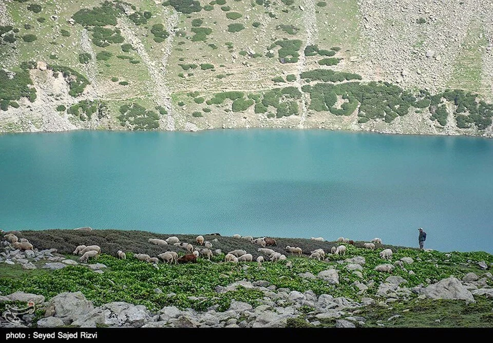
Gangabal, also written Gangbal and associated with the name Haramukh Ganga, is a mountain lake below Haramukh in Ganderbal district. Its water, surrounding slopes and proximity to Nundkol give it a distinctive high-mountain setting. The lake is a geographical feature and a place of cultural significance, rather than merely a named stop on a packaged trek.[1]
Lake and mountain
The Ganderbal administration identifies Gangabal at the foot of Haramukh among the district's notable lakes. A broad view can show the relationship between lake basin and mountain slopes, while the precise shoreline and tributary channels need more detailed mapping.[2]
Reference accounts associate the lake with Hindu pilgrimage and ritual memory. Religious significance belongs in the place's cultural history, while an account of lake formation requires geographical evidence. A sacred interpretation and a physical explanation answer different questions.[1]
Approach and landscape scale
Gangabal appears in descriptions of mountain walking routes, including approaches from the Naranag side. An itinerary and a lake profile should remain separate: reaching a mountain lake depends on route conditions, permissions and the traveller's actual starting point. A general directions link cannot survey a trail.[1]
A landscape photograph may include open ground, camps or grazing animals. Those are records of visible use at one time, not proof that camping or other activities are currently authorised everywhere around the lake. The caption's location and date matter when the image is used for practical interpretation.
Mountain lakes also differ from lakes in the settled valley floor. Their setting affects the way a visitor approaches them and the scale at which maps should be read. A point dropped on the water is useful for identification but unsuitable as a vehicle destination.
Compare Manasbal, Wular and Sheshnag for different Kashmir lake landscapes. Ganderbal supplies regional orientation. The map locates Gangabal, not an approved campsite, surveyed lakeside path or confirmed trailhead; current local information is required for an actual approach.
Image and map record
Image: Seyed Sajed Rizvi ??? ???? ??? ???? via Wikimedia Commons. Licence: CC BY 4.0. Recorded capture date: 2018-08-12. Resized and converted to WebP; image content unchanged. This is a dated view, not confirmation of the site’s present appearance.

Map marker: 34.43194444, 74.92583333. Source-recorded location for orientation; not a surveyed boundary, verified public entrance, current access guarantee or authorised stopping point. View location on OpenStreetMap · View Google Maps · Google directions · OpenStreetMap directions.
Research checked: 14 October 2026. For a visit, confirm current access, transport and opening information with the relevant authorities. This encyclopedia profile provides geographical and historical context.
Sources & references
[1] Reference overview: Gangabal Lake
https://en.wikipedia.org/wiki/Gangabal_Lake ↗
[2] Ganderbal administration: district geography
https://ganderbal.nic.in/about-district/ ↗
Image and licence
https://commons.wikimedia.org/wiki/File:Gangabal_Lake_13970520_01.jpg ↗
Related reading
Baltal: A Valley Camp and Pilgrimage Approach near Sonamarg
Baltal is a valley camp area near Sonamarg in Ganderbal district, widely associated with an approach to the Amarnath pilgrimage. The place and the sea
Dal Lake: Waterways, Floating Gardens and Life on the Lake
An introduction to Dal Lake’s connected basins, working waterscape, floating gardens, boats and cultural setting.
Ganderbal: Town and the Sind Valley Corridor
Ganderbal is a town and district headquarters in Kashmir's Sind valley corridor. The river and roads connect it with settlements and mountain approach