
Hanle: Settlement, Monastery and the High-altitude Night Sky
Hanle is a settlement in the high-altitude Changthang region of Ladakh, in the valley of the Hanle river.
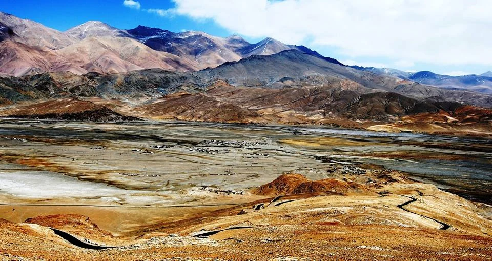
Hanle is a settlement in the high-altitude Changthang region of Ladakh, in the valley of the Hanle river. The name identifies an inhabited landscape, not merely an observatory or monastery. Published descriptions distinguish several hamlets within the wider village area and associate it with an older trade-route branch connecting Ladakh and Tibet. The village's history therefore predates its modern reputation for astronomy.[1]
Monastery and settlement
Hanle's monastery is associated with the Drukpa Kagyu tradition and the seventeenth century. It forms one element of a valley containing residential areas and working land. A photograph taken from a monastery hill may show the settlement below, but the religious complex and the settlement should retain separate identities in descriptions and map records.[1]
The government heritage inventory also records multiple heritage sites in Hanle, including the Dechen Namgyal Monastery. This provides a starting point for object-specific research instead of assuming that every old building has the same date or function. A village profile can connect these records while leaving each site's individual history open to closer examination.[2]
A village under a studied sky
The Indian Institute of Astrophysics describes its Hanle observatory as a high-altitude facility in a dry, cold-desert setting. The observatory adds a modern scientific layer to an already inhabited region. Its location should not be interpreted as evidence that the valley is empty, nor should a visitor experience be equated with access to working research equipment.[3]
That distinction is helpful for understanding the area's dark-sky reputation. Astronomical observation depends on conditions and infrastructure; local life has its own requirements. Lighting, accommodation and travel should be discussed through actual services and arrangements, with care for residents and scientific work. Avoiding glare near an observing site is a practical principle, while entry rules require current confirmation.
This encyclopedia assigns Hanle to the Changthang district framework notified in 2026; older descriptions may use Leh. Read the separate Indian Astronomical Observatory entry for the instruments and research context, and compare the lake landscapes of Tso Moriri and Tso Kar without assuming they are neighbouring attractions within walking distance.
Photograph and map record
Photograph: Vinay Goyal, Ludhiana via Wikimedia Commons. Licence: CC BY-SA 4.0. Recorded capture date: 2010-04-14. Resized and converted to WebP; scene content unchanged. This is a dated view, not confirmation of the site’s present appearance.

Map marker: 32.79, 79. Representative location from the secondary geographical record, not a surveyed boundary or verified visitor entrance. View location on OpenStreetMap · View Google Maps · Google directions · OpenStreetMap directions.
Research checked: 14 October 2026. For a visit, confirm current access, transport and opening information with the relevant authorities. This encyclopedia profile provides geographical and historical context.
Sources & references
[1] Hanle (village) — secondary historical/geographical overview
https://en.wikipedia.org/wiki/Hanle_%28village%29 ↗
[2] Ladakh heritage inventory: Hanle sites
https://heritage.ladakh.gov.in/hanle/sites ↗
[3] IIA: observatory and Hanle environment
https://www.iiap.res.in/outreach/hdsr/about/indian-astronomical-observatory/ ↗
Photograph and licence
https://commons.wikimedia.org/wiki/File:Hanle,_Ladakh,_India.jpg ↗
Related reading
Basohli: Ravi-side Town and a Centre of Pahari Painting
Basohli is a town in Kathua district, in the Jammu region, overlooking the Ravi river landscape.
Bhaderwah: Town, Valley and the Bhadarwahi Cultural Landscape
The mountain town and valley, local language identity and relationship with surrounding destinations.
Black-necked Crane: Wetland Breeding Habitat in Ladakh
The black-necked crane is an important bird of Ladakh's high-altitude wetland landscapes.